Ryongrim County
Ryongrim County is a kun, or county, in southeastern Chagang Province, North Korea. It borders Rangrim, Changjin, Chŏnch'ŏn, Tongsin, Taehŭng, and Sŏnggan counties. The county is mainly alpine territory. It contains many mountain peaks, such as Wagalbong (2,260m), Ch'ŏnŭimulsan (2,032m), Rangrimsan (2,186m), Milpuldŏksan (1,577m), Ungŏsusan (2,020m), Tomabong (1,525m), Paktalsan (1,817m), Taedasan (1,463m), and Sonamsan (1,178m).
Ryongrim County 룡림군 | |
|---|---|
| Korean transcription(s) | |
| • Hanja | 龍林郡 |
| • Hangul | South Korean: 용림군 |
| • McCune-Reischauer | Ryongrim kun |
| • Revised Romanization | South Korean: Yongnim-gun |
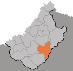 Map of Chagang showing the location of Ryongrim | |
| Country | North Korea |
| Province | Chagang Province |
| Administrative divisions | 1 ŭp, 12 ri |
In the standard dialect of South Korea, Ryongrim loses its initial 'r' both in pronunciation and spelling.
Administrative divisions
Ryongrim County is divided into 1 ŭp (town) and 12 ri (villages):
|
|
gollark: My Arch install fits in 20GB or so, and I could cut it further if I actually cared, has no ads, boots in 25 seconds off my SSD to a usable desktop including time to enter my encryption key and password, and runs blazing fast.
gollark: e. g. stupid preinstalled bloatware.
gollark: There can be issues other than hardware and drivers.
gollark: Noveau is as far as I know missing features, and also hard to spell.
gollark: They should just always use those.

This article is issued from Wikipedia. The text is licensed under Creative Commons - Attribution - Sharealike. Additional terms may apply for the media files.