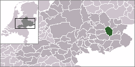
Ruurlo
Ruurlo is a town and former municipality in the province of Gelderland in the eastern part of the Netherlands. In 2004 it had a population of 8,676.
Ruurlo | |
|---|---|
Dorp | |
 Flag  Coat of arms | |
| Coordinates: 52°5′14″N 6°27′28″E | |
| Country | Netherlands |
| Province | Gelderland |
| Municipality | Berkelland |
| Area | |
| • Total | 54.94 km2 (21.21 sq mi) |
| Population (2008) | 7,830 |
|
| |
| Country | Netherlands |
| Province | Gelderland |
| Area - Land - Water |
65.19 km² 64.96 km² 0.23 km² |
| Population (2004) - Density |
8,676 134/km² |
The town has a station on the Zutphen to Winterswijk railway line, and is served by trains every half-hour in both directions. In the evening there is an hourly service.
Ruurlo Castle lies just outside the town and is a popular place for weddings. The castle was used as the town hall until 1 January 2005, when the municipality Ruurlo merged with the municipalities of Borculo, Neede and Eibergen into the municipality of Berkelland.
Population centres
Brinkmanshoek, De Bruil, De Haar, Heurne, Mariënvelde, Ruurlo and Veldhoek.
Transportation
- Railway station: Ruurlo
Gallery
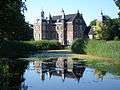 Ruurlo, Ruurlo castle
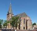 Ruurlo, reformed church
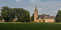 Ruurlo, church: de Sint Willibrorduskerk
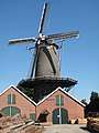 Ruurlo, windmill: houtzaagmolen de Agneta
gollark: Yes, it does*.
gollark: I guess so.
gollark: Okay, stuff is broken on my end maybe.
gollark: ++tel status
gollark: ++tel dial ShadyPoseStanza
External links
- Official Website
- J. Kuyper, Gemeente Atlas van Nederland, 1865-1870, "Ruurlo". Map of the former municipality, around 1868.
| Wikimedia Commons has media related to Ruurlo. |
| Authority control |
|
|---|
This article is issued from Wikipedia. The text is licensed under Creative Commons - Attribution - Sharealike. Additional terms may apply for the media files.