Rundēni Parish
Rundēni parish (Latvian: Rundēnu pagasts) is located in a southwest of Ludza District in Latvia, it borders on the Pildas, Nirza, Lauderu and Istras parishes (all: Ludza District), the Škaunes and Ezernieku parishes (both: Krāslava District) and the Kaunatas parish (Rezekne District). Distances: from parish centre - village of Rundēni up to District centre - Ludza is 33 km, up to the Capital of Latvia - Riga - 315 km.
 Village of Rundēni | |
| Country: | Latvia |
|---|---|
| Region: | Latgale |
| District: | Ludza District |
| Administrative centre: | Rundēni |
| Status: | from 1933 |
| Population: | 620 (2007) |
| Location: | 56°16′36.3″N 27°49′34.7″E |
Population and national structure
In the Census of 2000, from a population of 800, there were 231 residents of Latvian nationality, 522 Russians, and 23 Belarussians.
Landscape
| Total area | The agricultural land | Woods | Infrastructure | Melioration | |
|---|---|---|---|---|---|
| 100.00% | 47.45% | 39.89% | 6,70% | 5,96% | |
| 12466,5 ha | 5915.9 ha | 4972,7 ha | 835,1 ha | 742.8 ha | |
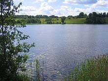
Rundēni parish is located on the height of Latgale. Most of the parish is covered by the hills of Razna, and in the south-east by hills of Dagda. The highest part of Rundēni parish is the northern part, which forms a watershed between the rivers Daugava and Velikaya (basin of Lake Pskov). The western part of the parish is close to the massif of Lielais Liepukalns. The highest hills are Pentjušu Hill, and also hills to the north at Kovaļiški, Sūnupļava and Rudzīši. The biggest lake is Lake Bižas. Smaller lakes include Bezersļesjes, Aunejas, Testečkovas, Kazeņa and Rudzīšu. The Saryanka River, a tributary of the Daugava, flows through the parish. Other small rivers of the parish are the Kazeņa, Siņica, Volčica, Vonogupīte.
Villages and populated places
The centre of the parish is the village of Rundēni. Other populated places include:
- Adelinova
- Barsuki
- Bezlesje
- Bļižņeva
- Bori
- Bojari
- Briževa
- Bubinova
- Čuhnova
- Dvorišče
- Devjatņiki
- Drozdovka
- Dzenegaļi
- Gorodoks
- Greidani
- Griņkova
- Homutova
- Kabilovka
- Kazeņa
- Kazici
- Kannova
- Kļeščeva
- Klumstova
- Kovaļiški
- Ksaverina
- Labunščina
- Lielā Maļinovka
- Lisova
- Loborži
- Losiški
- Mazkrinica
- Maļinovka
- Mačuļi
- Mežavēpri
- Nalogi
- Noviņi
- Noviydvors
- Opši
- Osova
- Ostrova
- Pakalni
- Pentjuši
- Pereļji
- Pešleva
- Posiški
- Punculova
- Pušča
- Rocova
- Rudzīši
- Ruleva
- Rusecki
- Sarja
- Savina
- Stankeviči
- Strukaļi
- Sūnupļava
- Tarčilova
- Tartaks
- Tereneva
- Testečkova
- Škorlupova
- Yačmenišče
- Vertulova
- Zamostje
- Zarečje
- Zirgi
- Zubova
- Žubuļi
History
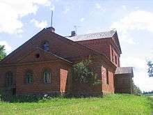
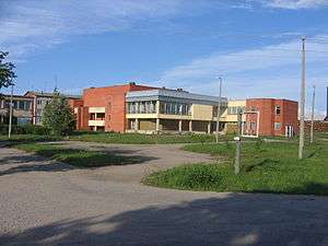
Early in its history, the parish included the manors Rundēni, Viktorinavas un Bišu and smaller half-manors Zuranpole, Čuhnova, and Lielā Kriņņica un Zaķu. During an agrarian reform, the manors were divided into land lots. The Pakalnu manor house is a private property, its architectural style is [[neo-romanticism] and park of Rundēni manor. Until 1938 there were schools: in Ruleva, Drozdovka, Rudzīši, Pakalni, Vertulova and Rundēni. In 1939 the Rundēni secondary school was constructed. In 1920-1930 in rural community were some companies are formed: agricultural, credit-savings and cattle breeding. There were two flour mills, a dairy, twelve grocery shops, two bakeries, shop of wine and vodka, and also shop of manufactory and leather products. During the Soviet era, the state farm at Rundēni was the largest in Ludza District.
Showplaces
Places of worship
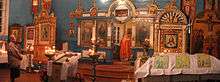
- The Roman Catholic Church of Christ's Ascension in Rundēni[1]
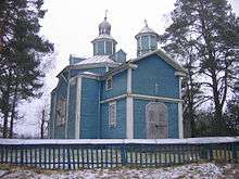
- The Orthodox Church of Birth of Our Lady in Vertulova
- The Orthodox Old Believers’ Church Chapels: Bližņeva and Bori.
Protected archaeological and cultural monuments
| Denomination | Location |
|---|---|
| Medieval cemetery of Vertulova | Vertulova |
| Gorodoks ancient hill fort I (Gorelaya hill, Gorodoks) | Gorodoks |
| Gorodoks ancient hill fort II (Krutaya hill, Kostyolnaya hill) | Gorodoks |
| Ancient burial ground in Zirgi | Zirgi |
| Ancient burial ground and the Bull-stone in Kazici | Kazici |
| Ancient burial ground in Pešļeva | Pešļeva |
| Ancient burial ground and settlement in Pentjuši | Pentjuši |
| Ancient burial ground in Tereņeva | Between Tereņeva and Kannova |
Natural monuments
The Bull-stone in Kazici is a big, ancient cult stone of the Baltic tribes. 5.3 m (17 ft) long, 3.5 m (11 ft) wide and 1.8 m (5.9 ft) tall. The Bull-stone may have served to designate an ancient border. According to local legends, it the stone is touched it will - that it takes away ailments and gives energy.
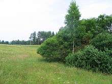
Rundēni Devil’s Pits is a natural monument covering 3 hectares (7.4 acres) at Height of Latgale, 3–4 km (1.9–2.5 miles) north-east of Rundēni near the Rundēni-Lauderi road. Since 1997 the Devil's Pits are a protected geomorphological object and are unique in the Baltic states. There are five pits of an unknown origin; one is filled with water and the others with raspberry bushes. The pits may have been caused by a meteorite or may be karstic formations.
Sculptural monuments and installations
- The Hill of Crosses[2]
- Memorial complex in Sūnupļava
The memorial ensemble was created in memory of eleven heroes of different nationalities, of World War II on Height of Sūnupļava (Height 144). It is on a roadside of the Rundēni-Lauderi road. The memorial ensemble is created from greater boulders (author A. Dripe).