Roumois
The Roumois (French: [ʁumwa]) is a region in the northwestern part of the Eure département in Normandy, France. It is a plateau situated southwest of Rouen. Its northern boundary is the Seine downstream of Elbeuf, its western boundary is the Risle valley. The plain of Le Neubourg lies to the south. The main towns of the Roumois are Bourg-Achard and Bourgtheroulde-Infreville. The landscape is similar to that of the Pays de Caux on the north side of the Seine.
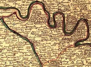
Map of the Roumois, 1716
The economy is mainly based on agriculture, but it is also influenced by the nearby Rouen agglomeration.
History
Encyclopédie Méthodique [1] [2]
gollark: That's basically the defining belief of most religions though? And the justification for believing in the religious book and such.
gollark: I, personally, consider myself tolerant of people who are tolerant of people who are tolerant of people who are tolerant of people to arbitrary depths of recursion.
gollark: The whole "religion and omnipotent god" thing drags along a lot of *other* bits.
gollark: Me? No, don't think so.
gollark: It's a major bit of it and as far as I know the justification for most things in it.
References
- "Roumois". Encyclopédie Méthodique: géographie (in French). 3. Panckoucke. 1788. p. 49. Retrieved 25 July 2017.
- Lajoye, Patrice (2007). "L'évolution du nom de Rouen dans l'Antiquité et au Haut Moyen Âge en domaines celtique, latin et germanique" (PDF). Annales de Normandie (in French). 57 (3): 223–229. Archived from the original on 25 July 2017. Retrieved 25 July 2017.
This article is issued from Wikipedia. The text is licensed under Creative Commons - Attribution - Sharealike. Additional terms may apply for the media files.