Rohrenkopf
The Rohrenkopf is a mountain, 1,169.8 m above sea level (NHN)[1] high, in the Southern Black Forest in Germany. It rises within the parish of Gersbach, a village in the borough of Schopfheim.
| Rohrenkopf | |
|---|---|
 Rohrenkopf | |
| Highest point | |
| Elevation | 1,170 m (3,840 ft) |
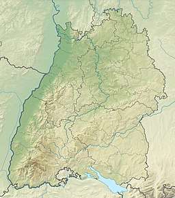
| Coordinates | 47°42′47″N 07°55′38″E |
| Geography | |
| Location | Baden-Württemberg, Germany |
| Parent range | Black Forest |
Geography
To the southwest is the county town (Kreisstadt) of Lörrach, 32 kilometres away.
The Rohrenkopf is Gersbach's highest point. In good weather the Swiss Alps may be seen, including the trio of the Eiger, Mönch and Jungfrau.
gollark: I've read the abstracts of *at least* two AI papers on an entirely different topic.
gollark: Not really anything, but at least this sort of fast control task.
gollark: Why? You could simulate mechanical faults and train the system on them.
gollark: Once again, I would be fine with that if their autopilot was good, which it isn't.
gollark: We could probably have a lot more automated stuff now if it wasn't for the difficulty of coordinating everyone on redesigning things at the same time.
References
- Map services of the Federal Agency for Nature Conservation
This article is issued from Wikipedia. The text is licensed under Creative Commons - Attribution - Sharealike. Additional terms may apply for the media files.