Rocotopunta (Recuay)
Rocotopunta[1][2] (Quechua rukutu, a plant (Capsicum pubescens) and Spanish punta, a peak or ridge)[3][4][5][6] is a mountain in the Cordillera Blanca in the Andes of Peru, about 4,400 m (14,436 ft) high.[2] It is located in the Ancash Region, Recuay Province, Ticapampa District, northeast of Lake Querococha. Rocotopunta lies between Yanamarey Creek to the north and Conde Creek to the south.[2]
| Rocotopunta | |
|---|---|
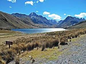 Lake Querococha and Rocotopunta (on the right) | |
| Highest point | |
| Elevation | 4,400 m (14,400 ft) [1] |
| Coordinates | 9°42′20″S 77°18′27″W |
| Geography | |
 Rocotopunta Peru | |
| Location | Peru, Ancash Region |
| Parent range | Andes, Cordillera Blanca |
References
- escale.minedu.gob.pe - UGEL map of Recuay Province (Ancash Region)
- Peru 1:100 000, Recuay (20-i). IGN (Instituto Geográfico Nacional - Perú).
- Teofilo Laime Ajacopa, Diccionario Bilingüe Iskay simipi yuyayk'ancha, La Paz, 2007 (Quechua-Spanish dictionary)
- Diccionario Quechua - Español - Quechua, Academía Mayor de la Lengua Quechua, Gobierno Regional Cusco, Cusco 2005 (Quechua-Spanish dictionary) (five-vowel-system)
- David Weber, A Grammar of Huallaga (Huánuco) Quechua, University of California Press, p. 185
- Robert Beér, Armando Muyolemaj, Dr. Hernán S. Aguilarpaj, Vocabulario comparativo, quechua ecuatoriano - quechua
This article is issued from Wikipedia. The text is licensed under Creative Commons - Attribution - Sharealike. Additional terms may apply for the media files.