Rock Island Railroad Bridge (Columbia River)
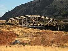
The Rock Island Railroad Bridge is BNSF Railway's bridge across the Columbia River, at Rock Island, Washington. The structure consists of one through truss, one deck truss, and an approach trestle.
Rock Island Railroad Bridge | |
|---|---|
 | |
| Coordinates | 47°22′02″N 120°09′07″W |
| Carries | 1 railroad track |
| Crosses | Columbia River |
| Locale | Rock Island, WA |
| Maintained by | BNSF Railway |
| Characteristics | |
| Design | Truss bridge |
| Total length | 875 feet (267 m) |
| Longest span | 416.5 feet (127 m) |
| History | |
| Opened | 1892 |
| Statistics | |
| Daily traffic | freight |
Rock Island Railroad Bridge | |
 | |
| Location | Spans Columbia River about 0.7 miles (1.1 km) southwest of Rock Island |
| Nearest city | Rock Island, Washington |
| Coordinates | 47°22′01″N 120°09′14″W |
| Area | 1 acre (0.4 ha) |
| Built | 1892 |
| Architect | Edge Moor Bridge Works |
| Architectural style | fixed span through truss br. |
| MPS | Historic Bridges/Tunnels in Washington State TR (AD) |
| NRHP reference No. | 75001842[1] |
| Added to NRHP | July 30, 1975 |
%26groups%3D_1098afadba073eddd04e48ce811fb70f957ceb9b.svg)
| |
History
The bridge was originally built in 1892 for the Great Northern Railway and was the first bridge to span the Columbia River. The site was chosen at Rock Island, Washington for being the shortest distance between the banks of the Columbia River in Washington state. In 1925, it was decided to strengthen the main span in anticipation of increased traffic and heavier trains by reinforcing the structure with an additional outside truss frame.[2]
gollark: /lignum is bad
gollark: /home
gollark: I tested that on lemmmy repeatedly.
gollark: Yes, I know.
gollark: I guess that's probably doable with regular player privileges and /home.
References
- "National Register Information System". National Register of Historic Places. National Park Service. March 13, 2009.
- "Nomination Form for Rock Island Railroad Bridge". National Park Service. and accompanying pictures
| Wikimedia Commons has media related to Rock Island Railroad Bridge (Columbia River). |
This article is issued from Wikipedia. The text is licensed under Creative Commons - Attribution - Sharealike. Additional terms may apply for the media files.

