River Mardle
The River Mardle is a tributary of the River Dart in Devon, England.
| River Mardle | |
|---|---|
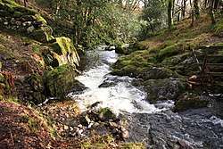 River Mardle near Chalk Ford | |
| Location | |
| Country | England |
| County | Devon |
| Physical characteristics | |
| Source | 50.507°N 3.881°W |
| • location | East of Ryder's Hill |
| • elevation | 430 m (1,410 ft) |
| Mouth | 50.482°N 3.766°W |
• location | River Dart |
• elevation | 30 m (98 ft) |
| Length | 10 km (6.2 mi) |
It rises on Holne Moor on Dartmoor and flows in a generally south-easterly direction. It forms a short part of the boundary of Dartmoor National Park near its confluence with Snowdon Brook and Chalk Ford, where it is crossed by the Two Moors Way. After this it flows through Scae Wood and then farmland until it reaches the town of Buckfastleigh where it passes under the A38 road and the South Devon Railway to meet the River Dart near Buckfastleigh railway station.
References
- Ordnance Survey 1:25,000 scale map of Dartmoor. OL28.
- Hemery, Eric (1983). High Dartmoor. London: Robert Hale. pp. 596–600. ISBN 0-7091-8859-5.
| Wikimedia Commons has media related to River Mardle. |
This article is issued from Wikipedia. The text is licensed under Creative Commons - Attribution - Sharealike. Additional terms may apply for the media files.