River E
The River E is a river in the Highlands of Scotland. It begins in the north-west of the Monadh Liath, to the south-east of Loch Ness. It runs in a north-westerly direction for about 10 km, before flowing into Loch Mhòr.[1][2][3]
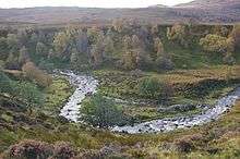
Horseshoe bend in the river
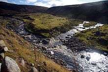
Confluence with the Allt a' Ghille Charaich
The river has a small hydro-electric scheme. This run-of-the-river scheme has a capacity of 3MW and is operated by RWE Npower. Construction of the scheme began in 2006, and it was commissioned in 2007.[4]
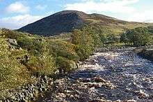
View along the river
The River E is among the shortest place names in the world.[5]
References
| Wikimedia Commons has media related to River E. |
- Ordnance Survey 1:50,000 scale Landranger map sheet 26 Inverness
- Ordnance Survey 1:25,000 scale Explorer
- Ordnance Survey 1:10,000 scale StreetView
- "River E Hydro Scheme". RWE Npower. Archived from the original on 1 April 2011. Retrieved 29 January 2011.
- Ash, Russell (10 November 2011). Boring, Botty and Spong. RHCP. p. 70. ISBN 978-1-4090-9739-6.
This article is issued from Wikipedia. The text is licensed under Creative Commons - Attribution - Sharealike. Additional terms may apply for the media files.