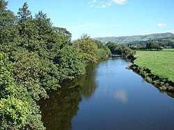
River Dyfi
The River Dyfi (Welsh: Afon Dyfi Welsh pronunciation: [ˈdəviː], sometimes anglicised as River Dovey /ˈdʌviː/,) is a river in Mid Wales. It is approximately 30 miles (48 km) long.[1] Its estuary forms the border between the counties of Gwynedd and Ceredigion, and its lower reaches have historically been considered the boundary between North and South Wales.[2][3]
| River Dyfi/Dovey Welsh: Afon Dyfi | |
|---|---|
 The river north of Machynlleth | |
| Location | |
| Country | Wales |
| Physical characteristics | |
| Source | Creiglyn Dyfi |
| • elevation | 1,900 ft (580 m) |
| Mouth | |
• location | Irish Sea |
| Length | 30 miles (48 km) |
Name
Nowadays the Welsh spelling Dyfi is widely used locally and by the Welsh Government,[4] Natural Resources Wales[5] and the BBC.[6] The anglicised spelling Dovey continues to be used by some entities.[7][8][9][10][11]
Sources
The River Dyfi rises in the small lake Creiglyn Dyfi at about 1,900 feet (580 m) above sea level, below Aran Fawddwy,[12] flowing south to Dinas Mawddwy and Cemmaes Road (Welsh: Glantwymyn), then south west past Machynlleth to Cardigan Bay (Welsh: Bae Ceredigion) at Aberdyfi. It shares its watershed with the River Severn (Welsh: Afon Hafren) and the River Dee (Welsh: Afon Dyfrdwy)[13] before flowing generally south-westwards down to a wide estuary. The only large town on its route is Machynlleth.
Because of its origins high in the Cambrian Mountains and its relatively short length, it is prone to flooding and some roads in the lower catchment can become impassable during very wet weather. It has been a relatively pristine river with few polluting inputs and is notable for its Salmon and Sea trout (migratory Brown trout).[14]
The catchment area is notable for its now-defunct lead mines and slate quarries, especially around Corris and Dinas Mawddwy.
Tributaries
The main tributaries of the River Dyfi are:
- Afon Leri at Ynyslas[13]
- Afon Clettwr north of Tre'r Ddol
- Nant y Gog at Eglwys Fach[12]
- Afon Einion at between Eglyws Fach and Glandyfi
- Afon Llyfnant at Glandyfi[13]
- North Dulas at Ffridd Gate[1]
- South Dulas east of Machynlleth
- Afon Ceirig at Mathafarn
- Afon Twymyn upstream of Cemmaes Road (Glantwymyn)
- Afon Angell at Aberangell
- Afon Cleifion at Mallwyd
- Afon Cerist at Dinas Mawddwy
- Afon Cywarch at Aber-Cywarch
Dyfi Bridge
The road bridge which crosses the river north of Machynlleth is a landmark.[15]
Dyfi Biosphere
The area around Aberystwyth and the Dyfi Valley is known as the Dyfi Biosphere (Welsh: Biosffer Dyfi). It was UNESCO-designated in 1978.[16][17] Within the biosphere are a number of Special Areas of Conservation and Sites of Special Scientific Interest (Cors Fochno, Coed Cwm Einion and Pen Llŷn a’r Sarnau).
Film Location
The Dyfi estuary was used as a location shot in Led Zeppelin's 1976 film The Song Remains the Same. The segment of the film is where Robert Plant comes ashore on a boat, after which he rides a horse, making his way to Raglan Castle. Plant was obviously behind the choice of the location, being familiar with the area; Bron-Yr-Aur cottage is located on the edge of Machynlleth.
References
- Penny Cyclopaedia of the Society for the Diffusion of Useful Knowledge. C. Knight. 1839. pp. 111–.
- Alex Kendall (30 March 2017). The Snowdonia Way: A walking route through Snowdonia from Machynlleth to Conwy. Cicerone Press. pp. 37–. ISBN 978-1-78362-455-3.
- John Murray (publishers.) (1861). Handbook for travellers in North Wales. pp. 142–.
- "A487: new Dyfi bridge (overview)". Welsh Government. Retrieved 8 August 2019.
- "Natural Resource Management in the Dyfi". Natural Resources Wales. Retrieved 24 June 2019.
- "Dinas Mawddwy bridge reopens after safety fear closure". BBC News. 4 August 2017. Retrieved 24 June 2019.
- "Aberdyfi (scroll down south)". Ordnance Survey. Retrieved 25 June 2019.
- "Dovey Junction (DVY) station details". National Rail Enquiries. Retrieved 25 June 2019.
- "The Dovey Valley Hotel". Yell.com. Retrieved 24 June 2019.
- "BE IN TOUCH..." Dovey Marine. Retrieved 24 June 2019.
- "Contact". Dovey Yacht Club. Retrieved 24 June 2019.
- Stuart Fisher (5 January 2012). Rivers of Britain: Estuaries, Tideways, Havens, Lochs, Firths and Kyles. Bloomsbury Publishing. pp. 47–. ISBN 978-1-4081-5931-6.
- Royal Commission on Land in Wales and Monmouthshire (1896). Reports: With Minutes of Evidence and Appendices. H. M. Stationery Office. pp. 27–28.
- Erichsen Jones, J. R. (May 1941). "The Fauna of the River Dyfi, West Wales". Journal of Animal Ecology. British Ecological Society. 10 (1): 12–24. doi:10.2307/1339. JSTOR 1339.
- "Pont ar Ddyfi Bridge, Machynlleth". Gwynedd Archaeological Trust. Retrieved 28 August 2017.
- Danielle Sinnett; Nick Smith; Sarah Burgess (27 November 2015). Handbook on Green Infrastructure: Planning, Design and Implementation. Edward Elgar Publishing. pp. 359–. ISBN 978-1-78347-400-4.
- The Dyfi Biosphere website