Ring 1 (Aarhus)
Ring 1, or Ringgaden, is a ring road that surrounds the most central part of Aarhus, Denmark, roughly bounding the neighborhood of Midtbyen. It is part of the Danish national road network and is numbered O1, denoting a ring road. The total length of the road is about 8.8 km.
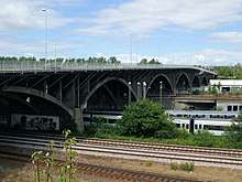
Ring 1 (Ringgaden). The bridge of Ringgadebroen, crossing the railway yard.
Geography
Ring 1 connects the major road Marselis Boulevard in the south with Grenåvej in the north at Marienlund. Ringgaden is subdivided according to the geographical location and is named like this (south to north):
| Road name |
|---|
| Sønder Ringgade |
| Ringgadebroen |
| Vestre Ringgade |
| Nordre Ringgade |
History
Ideas for a ring road around Aarhus materialised politically in 1919, and it was subsequently constructed in several stages, beginning in 1923 and finishing in 1938.[1]
gollark: Worrying.
gollark: Is there a repair or fsck tool you can run?
gollark: The popular example is those Therac machines, but IIRC they didn't cause that many deaths compared to this.
gollark: It annoys me that papers aren't shipped as HTML or something which I can actually view conveniently at different screen sizes.
gollark: I wonder if they made some kind of Verilog to JBIG2 compiler internally.
See also
References
- See "Nordre Ringgade".
Sources
- Aarhus Municipality: Nordre Ringgade, Kommuneatlas (in Danish)
This article is issued from Wikipedia. The text is licensed under Creative Commons - Attribution - Sharealike. Additional terms may apply for the media files.