Ricarville
Ricarville is a former commune in the Seine-Maritime department in the Normandy region in northern France. On 1 January 2017, it was merged into the new commune Terres-de-Caux.[2]
Ricarville | |
|---|---|
Part of Terres-de-Caux | |
 Coat of arms | |
Location of Ricarville 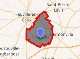
| |
 Ricarville  Ricarville | |
| Coordinates: 49°38′15″N 0°36′30″E | |
| Country | France |
| Region | Normandy |
| Department | Seine-Maritime |
| Arrondissement | Le Havre |
| Canton | Saint-Valery-en-Caux |
| Commune | Terres-de-Caux |
| Area 1 | 4.18 km2 (1.61 sq mi) |
| Population (2017)[1] | 305 |
| • Density | 73/km2 (190/sq mi) |
| Time zone | UTC+01:00 (CET) |
| • Summer (DST) | UTC+02:00 (CEST) |
| Postal code | 76640 |
| Elevation | 118–145 m (387–476 ft) (avg. 145 m or 476 ft) |
| Website | https://ricarville.terres-de-caux.fr/ |
| 1 French Land Register data, which excludes lakes, ponds, glaciers > 1 km2 (0.386 sq mi or 247 acres) and river estuaries. | |
Geography
A farming village in the Pays de Caux, situated some 25 miles (40 km) northeast of Le Havre, in the triangle formed by the D928, D40 and the A29 autoroute.
Heraldry
Arms of Ricarville |
The arms of Ricarville are blazoned : Quarterly 1: Argent, 3 fesses gules; 2: Azure, a tower open of the field Or masoned sable; 3: Azure, a cross fleurdelysée Or; 4: Argent, a chevron gules. |
Population
| 1962 | 1968 | 1975 | 1982 | 1990 | 1999 | 2006 |
|---|---|---|---|---|---|---|
| 199 | 205 | 170 | 276 | 307 | 306 | 319 |
| Starting in 1962: Population without duplicates | ||||||
Places of interest
- The church of the Trinity, dating from the thirteenth century.
gollark: Just implement Georgism. This cannot fail.
gollark: You should worry about things before they happen, because worrying about them afterward introduces numerous technical difficulties.
gollark: I am not actually in the US.
gollark: I don't think anyone has good *video* generation yet because lots more data and worse datasets.
gollark: I think kitebot has commands to pull from a few.
References
- Téléchargement du fichier d'ensemble des populations légales en 2017, INSEE
- Arrêté préfectoral 12 September 2016 (in French)
External links
| Wikimedia Commons has media related to Ricarville. |
- Ricarville on the Quid website (in French)
| Authority control |
|
|---|
This article is issued from Wikipedia. The text is licensed under Creative Commons - Attribution - Sharealike. Additional terms may apply for the media files.