Rehsiepen (Schmallenberg)
Rehsiepen is a locality in the municipality Schmallenberg in the High Sauerland District in North Rhine-Westphalia, Germany.
Rehsiepen | |
|---|---|
Stadtteil of Schmallenberg | |
 | |
Location of Rehsiepen %26groups%3D_fb2d43e07051794002966d18e84602b86733ce6e.svg)
| |
 Rehsiepen  Rehsiepen | |
| Coordinates: 51°11′46″N 8°24′47″E | |
| Country | Germany |
| State | North Rhine-Westphalia |
| Admin. region | Arnsberg |
| District | Hochsauerlandkreis |
| Town | Schmallenberg |
| Population (2019-12-31) | |
| • Total | 112 |
| Time zone | CET/CEST (UTC+1/+2) |
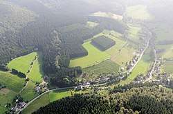
The village has 112 inhabitants[1] and lies in the east of the municipality of Schmallenberg at a height of around 556 m on the Landstraße 742. The river Sorpe flows through the village. Rehsiepen borders on the villages of Obersorpe, Altastenberg and Nesselbach.
Rehsiepen was first mentioned around 1600 as name in the statistics of the village Oberkirchen. The village used to belong to the municipality of Oberkirchen in Amt Schmallenberg until the end of 1974.[2]
Gallery
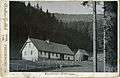 Old forester's lodge, 1899
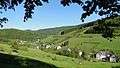 Rehsiepen, winter side
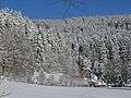 Rehsiepen, winter 2009
gollark: Wow, 412 new messages?
gollark: nil is falsy, so yes.
gollark: Roughly, although it's if x is *falsy* and not *nil* as far as I know.
gollark: Hmm, I *could* steal Unitcorrector.
gollark: Which one is yours?
External links
- Rehsiepen (Sorpetal) (in German)
References
- Schmallenberg.de: Inhabitants (in German)
- Statistisches Bundesamt (Hrsg.): Historisches Gemeindeverzeichnis für die Bundesrepublik Deutschland. Namens-, Grenz- und Schlüsselnummernänderungen bei Gemeinden, Kreisen und Regierungsbezirken vom 27.5.1970 bis 31.12.1982. W. Kohlhammer, Stuttgart/Mainz 1983, ISBN 3-17-003263-1, S. 335 f.
| Authority control |
|
|---|
This article is issued from Wikipedia. The text is licensed under Creative Commons - Attribution - Sharealike. Additional terms may apply for the media files.