Razgrad Peak
Razgrad Peak (Bulgarian: връх, romanized: vrah Razgrad, IPA: [ˈvrɤx ˈrazɡrɐt]) is an ice-covered peak rising to 550 m in Breznik Heights, Greenwich Island, Antarctica. The peak is located 740 m southeast of Terter Peak, 1.7 km southwest of Momchil Peak, 2.7 km west of the summit of Viskyar Ridge, and 1.51 km north-northeast of the coastal point formed by Ephraim Bluff (Bulgarian topographic survey Tangra 2004/05). An eastern offshoot of the peak is forming Maystora Peak. Surmounting Zheravna Glacier to the east and Wulfila Glacier to the west.
| Razgrad Peak | |
|---|---|
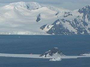
 Razgrad Peak from Kuzman Knoll, with Half Moon Island in the foreground | |
| Highest point | |
| Elevation | 550 m (1,800 ft) |
| Coordinates | 62°32′39″S 59°42′38″W |
| Geography | |
| Location | Greenwich Island, Antarctica |

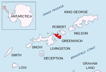
Location of Greenwich Island in the South Shetland Islands.

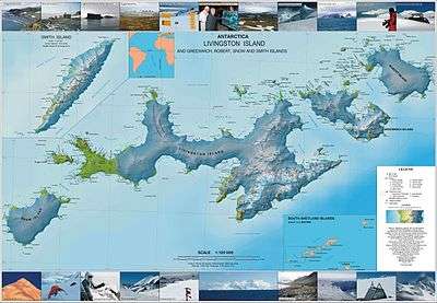
Topographic map of Livingston Island, Greenwich, Robert, Snow and Smith Islands.
The peak is named after the city of Razgrad in Northeastern Bulgaria.
Maps
- L.L. Ivanov et al. Antarctica: Livingston Island and Greenwich Island, South Shetland Islands. Scale 1:100000 topographic map. Sofia: Antarctic Place-names Commission of Bulgaria, 2005.
- L.L. Ivanov. Antarctica: Livingston Island and Greenwich, Robert, Snow and Smith Islands. Scale 1:120000 topographic map. Troyan: Manfred Wörner Foundation, 2009. ISBN 978-954-92032-6-4
gollark: You could kind of argue that the small embedded potatosystem on the PotatOS OmniDisk is potatOS-derived, but that doesn't share *much* code.
gollark: There's PotatOS Classic, PotatOS Tau (the main version), GovOS (developed for Keansia), ChorOS (for running Chorus City systems), PotatOS Tetrahedron (WIP dev version with mildly less awful code), TomatOS/BurritOS/YomatOS (I mean, same ideas, they don't share a huge amount of code).
gollark: <@107118134875422720> There are actually more potatOS-derived OSes than that.
gollark: Basically, yes.
gollark: SPUDNET in potatOS uses Polychoron for this.
References
- Razgrad Peak. SCAR Composite Gazetteer of Antarctica
- Bulgarian Antarctic Gazetteer. Antarctic Place-names Commission. (details in Bulgarian, basic data in English)
External links
- Razgrad Peak. Copernix satellite image
This article includes information from the Antarctic Place-names Commission of Bulgaria which is used with permission.
This article is issued from Wikipedia. The text is licensed under Creative Commons - Attribution - Sharealike. Additional terms may apply for the media files.