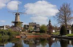
Ravenstein, Netherlands
Ravenstein (population: 8,466) is a city and a former municipality in the south of the Netherlands, in the province of North Brabant. The former municipality covered an area of 42.68 km² (of which 0.96 km² water). In 2003 it was incorporated into the city of Oss.
Lordship of Ravenstein | |||||||||
|---|---|---|---|---|---|---|---|---|---|
| 1368–1528 | |||||||||
| Status | Lordship | ||||||||
| Capital | Ravenstein | ||||||||
| Government | Lordship | ||||||||
| Historical era | Middle Ages | ||||||||
• Castle and town founded | 1358 | ||||||||
• Established | 1368 | ||||||||
• Gained city rights | 1380 | ||||||||
• Annexed by Cleves | 1528 | ||||||||
| |||||||||

Ravenstein also included the following towns, villages and townships: Demen, Dennenburg, Deursen, Dieden, Herpen, Huisseling, Keent, Koolwijk, Neerlangel, Neerloon, Overlangel. There is also a primary school called 'Ravenstein', in Flushing (Dutch: Vlissingen).
Ravenstein received city rights in 1380.
Dieden, Demen en Langel was a separate municipality until 1923, when it was merged with Ravenstein.[1]
Transport
Ravenstein lies directly to the A50, the highway from Eindhoven to Nijmegen. Close is Paalgraven junction, where the A59 divericates to 's-Hertogenbosch (25 km) and the A2 (20 km), the main road from north to south in the Netherlands.
History of the Lordship of Ravenstein
In 1397, Duke Adolph I of Cleves became Lord of Ravenstein.
See also
- Duchy of Cleves, later Cleves-Jülich
- War of the Jülich Succession
External links
- Tourist information about Ravenstein
- An American photoblogger in Ravenstein
- J. Kuyper, Gemeente Atlas van Nederland, 1865-1870, "Ravestein". Map of the municipality around 1868.