Rauhhügel
The Rauhhügel is an 812.9 m high (above sea level) mountain located in the Thuringian Highland, Thuringia (Germany).
| Rauhhügel | |
|---|---|
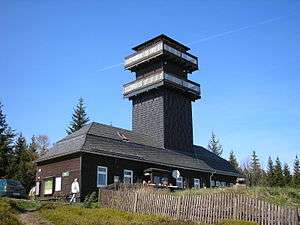 Leipzig tower on top of the Rauhhügel | |
| Highest point | |
| Elevation | 801.9 m (2,631 ft) |
| Coordinates | 50°32′36″N 11°13′2″E |
| Geography | |
| Parent range | Thuringian Forest |
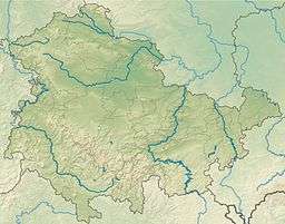
It is located close to the municipalities of Schmiedefeld and Lichte and the Leibis-Lichte Dam in the Saalfeld-Rudolstadt district in the Thuringian Forest Nature Park within walking distance of the Rennsteig.
| Description | Height above sea level |
Direction | Particularity |
|---|---|---|---|
| Mutzenberg | 770.0 m | SW | Coniferous forest |
| Spitzer Berg | 790.3 m | W NW | Coniferous forest |
| Rehhecke | 707.0 m | NW | Coniferous forest |
| Assberg | 703.0 m | N NE | |
The Leipzig tower on top of the Rauhhügel is 17.5 m high. It has viewing platforms on two levels, the upper at 14 m,[1] from which in good weather one can see far into the surrounding mountains of the Thuringian Highland, the Thuringian Forest and to mountains of the Fichtelgebirge and the Erzgebirge, including:
- Neuhaus am Rennweg (830 m)
- Ochsenkopf, (1.024 m) Fichtelgebirge
- Schneekopf, (1.051 m) Fichtelgebirge
- Fichtelberg, (1.214 m) Erzgebirge
There is a guesthouse at the base of the tower.
References
- Leipziger Turm Archived 2007-10-17 at the Wayback Machine, Olitätenland, retrieved March 26, 2011 (in German)
See also
- List of Mountains and Elevations of Thuringia
This article is issued from Wikipedia. The text is licensed under Creative Commons - Attribution - Sharealike. Additional terms may apply for the media files.