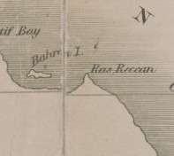
Ras Rakan
Ras Rakan (Arabic: رأس راكان) is the northernmost point in the Qatari Peninsula, located in Al Shamal.[1] It is the north-western point of an islet called Jazirat Ras Rakan, but as the channel between this islet and the mainland is not passable for boats, Jazirat Ras Rakan may be regarded as forming the northern extremity of the promontory.[2]

Location
The islet is nearly 1 ½ miles from the shore, and may be reached by wading through low water. The northernmost town of Qatar, Ar Ru'ays, lies 2 ½ miles south-east from the islet.[2] If approached at from a northward direction, Ar Ru'ays becomes visible before Ras Rakan is spotted.[3]
Description
Jazirat Ras Rakkan is a very low, T-shaped islet, with tufts of grass on it.[2] There are some small mangroves on the southern side of it.[4] It is nearly 2 miles in length east to west, and extremely narrow. The T-head, at its western end, is 1 mile long.[2]
Hydrology
In a 2010 survey of Ras Rakan's coastal waters conducted by the Qatar Statistics Authority, it was found that its average depth was 3.5 meters (11 ft) and its average pH was 7.74. Furthermore, the waters had a salinity of 48.18 psu, an average temperature of 19.61°C and 4.86 mg/L of dissolved oxygen.[5]
References
- Bird, Eric (2010). Encyclopedia of the World's Coastal Landforms. Springer. p. 1038. ISBN 978-1402086380.
- "'Gazetteer of Arabia Vol. II' [1557] (636/688)". Qatar Digital Library. 1917. Retrieved 31 December 2015. This article incorporates text from this source, which is in the public domain.
- "'Persian Gulf pilot comprising the Persian Gulf and its approaches from Ras al Hadd, in the south-west, to Cape Monze, in the east.' [132v] (269/404)". Qatar Digital Library. 1932. Retrieved 31 December 2015. This article incorporates text from this source, which is in the public domain.
- The Persian Gulf pilot: comprising the Persian Gulf, Gulf of Omán; and Makran coast. Great Britain: Hydrographic Dept. 1890. p. 127.
- "Qatar Infrastructure Statistics" (PDF). Qatar Statistics Authority. May 2012. p. 29. Retrieved 18 March 2019.