Ranyari Point
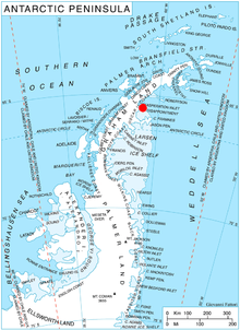
Ranyari Point (Bulgarian: нос Раняри, ‘Nos Ranyari’ \'nos ra-'nya-ri\) is the rounded ice-covered point on the southeast side of the entrance to Durostorum Bay on Oscar II Coast in Graham Land. It is situated on the north coast of Akra Peninsula, and was formed as a result of the break-up of Larsen Ice Shelf in the area in the early 21st century. Named after the Bulgar ruler Ranyari (6th century).
Location of Heros Peninsula in Graham Land, Antarctic Peninsula.
Location
Ranyari Point is located at 65°31′53″S 61°49′00″W, which is 6.7 km southeast of Sandilh Point and 5.2 km west of the north extremity of Cape Disappointment. SCAR Antarctic Digital Database mapping in 2012.
Maps
- Antarctic Digital Database (ADD). Scale 1:250000 topographic map of Antarctica. Scientific Committee on Antarctic Research (SCAR). Since 1993, regularly upgraded and updated.
gollark: There was also that Springer free textbook thing if it's still on.
gollark: For example, if someone claims that the mainstream establishment has been suppressing it or something, or if they talk about outlandish things which go against existing better-known science.
gollark: Nope. There are rough heuristics, though.
gollark: It looks vaguely like my bismuth thing in shape, but not color or anything.
gollark: It would be better to teach transferable stuff like "actually reading safety manuals".
References
- Ranyari Point. SCAR Composite Antarctic Gazetteer.
- Bulgarian Antarctic Gazetteer. Antarctic Place-names Commission. (details in Bulgarian, basic data in English)
External links
- Ranyari Point. Copernix satellite image
This article includes information from the Antarctic Place-names Commission of Bulgaria which is used with permission.
This article is issued from Wikipedia. The text is licensed under Creative Commons - Attribution - Sharealike. Additional terms may apply for the media files.