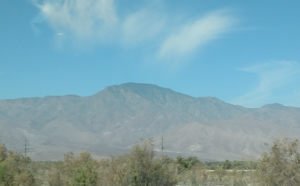
Rabbit Peak
Rabbit Peak is a mountain in the southern part of the Santa Rosa Mountains in the Peninsular Ranges in California. It is located in Riverside County in the Santa Rosa and San Jacinto Mountains National Monument near the border of San Diego County and the Anza-Borrego Desert State Park. It has an elevation of 6,653 feet (2,028 meters).[1] It is located 14 miles northeast of Borrego Springs and 20 miles south of Indio.
| Rabbit Peak, California | |
|---|---|
 | |
| Highest point | |
| Elevation | 6,653 ft (2,028 m) NAVD 88[1] |
| Prominence | 1,200 ft (370 m) [1] |
| Coordinates | 33°26′01″N 116°14′22″W [1] |
| Geography | |
 Rabbit Peak, California | |
| Location | Riverside County, California, U.S. |
| Parent range | Santa Rosa Mountains in the Peninsular Ranges |
| Topo map | USGS Rabbit Peak |
The peak has been described as the hardest mountain to climb in Southern California due to elevation gain of the trails and the lack of water along those trails.[2]
References
- "Rabbit Peak, California". Peakbagger.com. Retrieved 2019-06-15.
- Harris Afoot and Afield: Inland Empire
This article is issued from Wikipedia. The text is licensed under Creative Commons - Attribution - Sharealike. Additional terms may apply for the media files.