Río Arriba, Arecibo, Puerto Rico
Río Arriba is a barrio in the municipality of Arecibo, Puerto Rico. Its population in 2010 was 858.[3][4][5]
Río Arriba | |
|---|---|
Barrio | |
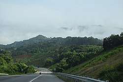 PR-10 in Río Arriba in Arecibo | |
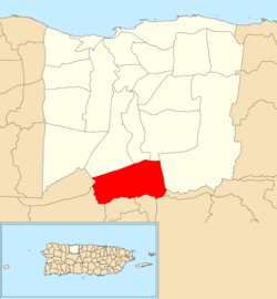 Location of Río Arriba within the municipality of Arecibo shown in red | |
 Río Arriba Location of Puerto Rico | |
| Coordinates: 18°20′28″N 66°41′02″W[1] | |
| Commonwealth | |
| Municipality | |
| Area | |
| • Total | 8.84 sq mi (22.9 km2) |
| • Land | 8.44 sq mi (21.9 km2) |
| • Water | 0.40 sq mi (1.0 km2) |
| Elevation | 1,119 ft (341 m) |
| Population (2010) | |
| • Total | 858 |
| • Density | 101.7/sq mi (39.3/km2) |
| Source: 2010 Census | |
| Time zone | UTC−4 (AST) |
History
The United States took control of Puerto Rico from Spain in the aftermath of the Spanish-American War under the terms of the Treaty of Paris of 1898. In 1899, the United States conducted its first census of Puerto Rico finding that the population of Río Arriba barrio was 1,709.[6]
Sectors
Barrios (which are like minor civil divisions)[7] in turn are further subdivided into smaller local populated place areas/units called sectores (sectors in English). The types of sectores may vary, from normally sector to urbanización to reparto to barriada to residencial, among others.[8][9][10]
The following sectors are in Río Arriba barrio:[11][12]
Sector Central Hidroeléctrica, Sector Cuerpo de Paz, Sector Dos Bocas, Sector El Valle, Sector Jobo, Sector La Canina I y II, Sector Los Chorros, and Sector Vacupey.
Hurricane Maria
On September 27, 2017 it was reported that a week after Hurricane Maria hit Puerto Rico, roads into and out of Río Arriba remained blocked and inaccessible. Residents were clearing the way with machetes and working with rescue crew to evacuate people who needed dialysis and emergency medical help.[13]
References
- "US Gazetteer 2019". US Census. US Government.
- U.S. Geological Survey Geographic Names Information System: Río Arriba barrio
- Picó, Rafael; Buitrago de Santiago, Zayda; Berrios, Hector H. Nueva geografía de Puerto Rico: física, económica, y social, por Rafael Picó. Con la colaboración de Zayda Buitrago de Santiago y Héctor H. Berrios. San Juan Editorial Universitaria, Universidad de Puerto Rico,1969.
- Gwillim Law (20 May 2015). Administrative Subdivisions of Countries: A Comprehensive World Reference, 1900 through 1998. McFarland. p. 300. ISBN 978-1-4766-0447-3. Retrieved 25 December 2018.
- Puerto Rico:2010:population and housing unit counts.pdf (PDF). U.S. Dept. of Commerce, Economics and Statistics Administration, U.S. Census Bureau. 2010.
- Joseph Prentiss Sanger; Henry Gannett; Walter Francis Willcox (1900). Informe sobre el censo de Puerto Rico, 1899, United States. War Dept. Porto Rico Census Office (in Spanish). Imprenta del gobierno. p. 160.
- "US Census Barrio-Pueblo definition". factfinder.com. US Census. Archived from the original on 13 May 2017. Retrieved 5 January 2019.
- "Agencia: Oficina del Coordinador General para el Financiamiento Socioeconómico y la Autogestión (Proposed 2016 Budget)". Puerto Rico Budgets (in Spanish). Retrieved 28 June 2019.
- Rivera Quintero, Marcia (2014), El vuelo de la esperanza: Proyecto de las Comunidades Especiales Puerto Rico, 1997-2004 (first ed.), San Juan, Puerto Rico Fundación Sila M. Calderón, ISBN 978-0-9820806-1-0
- "Leyes del 2001". Lex Juris Puerto Rico (in Spanish). Retrieved 24 June 2020.
- "PRECINTO ELECTORAL ARECIBO 026" (PDF). Comisión Estatal de Elecciones (in Spanish). PR Government. 19 October 2018. Retrieved 2 August 2020.
- "PRECINTO ELECTORAL ARECIBO 027" (PDF). Comisión Estatal de Elecciones (in Spanish). PR Government. 8 October 2019. Retrieved 2 August 2020.
- "Incomunicados en el barrio Río Arriba". Primera Hora (in Spanish). September 27, 2017.