Quincy Dredge Number Two
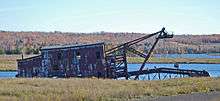
The Quincy Dredge Number Two (previously known as the Calumet and Hecla Dredge Number One) is a dredge currently sunk in shallow water in Torch Lake, across M-26 from the Quincy Mining Company Stamp Mills Historic District and just east of Mason in Osceola Township.[2] It was constructed to reclaim stamping sand from the lake for further processing, and was designated a Michigan State Historic Site in 1978.[1]
| Calumet and Hecla/Quincy Reclaiming Sand Dredge | |
|---|---|
 | |
| Location | M-26 near Torch Lake, Osceola Township |
| Coordinates | 47°8′39″N 88°27′35″W |
| Built | 1914 |
| Governing body | State |
| Designated | July 26, 1978[1] |
 Location of Calumet and Hecla/Quincy Reclaiming Sand Dredge in Michigan | |
History


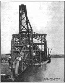
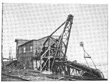
The Reclaiming Sand Dredge was constructed for the Calumet and Hecla Mining Company in 1914 by the Bucyrus Company of South Milwaukee, Wisconsin,[3] and designated the Calumet and Hecla Dredge Number One.[1] The dredge was used to reclaim previously-milled sand deposited in the lake after it had gone through the stamp mill.[4] The dredged sand contained copper that earlier stamping technology had not been able to separate out.[4] Improvements in stamping efficiency and cost increases in traditional shaft mining made these sand tailings economically feasible to reclaim and re-stamp.[4]
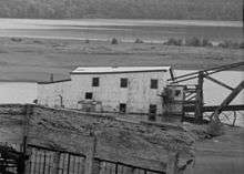
Calumet and Hecla used the dredge at their Lake Linden Reclamation Plant until 1951.[2] In 1951, the Quincy Mine purchased the dredge and designated it as their Quincy Dredge Number Two, using it at their own reclamation facility,[2][4] which had been in operation since 1943.[5] The mine's Quincy Dredge Number One sank in 1956, and Dredge Number Two was used until 1967,[2] when it too sank during a winter lay-up.[4] By this time, copper prices had fallen low enough that the reclamation process was not profitable, and the Quincy Mine abandoned both the dredge and its reclamation facility.[4]
Description
The dredge is a large, box-like vessel that was used to remove sand from the bottom of the lake.[2] The vessel has a steel hull measuring 110 feet (34 m) long, 56 feet (17 m) wide, and nine feet (2.7 m) deep.[3] The decking overhangs the hull by eight feet (2.4 m) per side, giving an overall width of 72 feet (22 m).[3] The dredge could process over 10,000 short tons (9,100 t) of sand per day, and had a 141-foot (43 m) suction pipe that could work in 115 feet (35 m) of water.[2]
The dredge is currently sunk in shallow water, and canted over to one side.[4] Most of the superstructure and the large boom are visible above the waterline.[4]
References
- "Calumet and Hecla/Quincy Reclaiming Sand Dredge". Historic Sites Online. Michigan State Housing Development Authority. Archived from the original on May 24, 2012. Retrieved November 20, 2010.
- Molloy, Lawrence J. (2001). "A Guide to Michigan's Historic Keweenaw Copper District". Retrieved November 25, 2010.
- Ives, L. E. (November 17, 1914). "The Calumet & Hecla Dredge". Engineering and Mining Journal. 98 (19): 811–3.
- "Quincy Dredge". Keweenaw Free Guide. Retrieved November 26, 2010.
- Hyde, Charles K. (c. 1968). "An Economic and Business History of the Quincy Mining Company". Quincy Mining Company, Hancock, Houghton, MI, HAER MI-2. Historic American Buildings Survey/Historic American Engineering Record/Historic American Landscapes Survey. p. 264.