Qanchis Kancha
Qanchis Kancha (Quechua qanchis seven, kancha corral,[2] "seven corrals", Hispanicized spelling Janchiscancha) is a mountain in the Andes of Peru, about 5,000 metres (16,404 ft) high. It is situated in the Lima Region, Huarochiri Province, Chicla District.[1] Qanchis Kancha lies near the Antikuna mountain pass, southwest of Tikti Mach'ay and Jirish Mach'ay.
| Qanchis Kancha | |
|---|---|
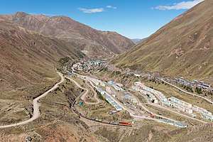 The mining village of Q'asa P'allqa (Casapalca) and the eastern slope of Qanchis Kancha (on the right) as seen from Jirish Mach'ay, looking to the south. | |
| Highest point | |
| Elevation | 5,000 m (16,000 ft) [1] |
| Coordinates | 11°37′55″S 76°14′49″W |
| Geography | |
 Qanchis Kancha Peru | |
| Location | Peru, Lima Region |
| Parent range | Andes |
References
- escale.minedu.gob.pe - UGEL map of the Huarochiri Province (Lima Region)
- Teofilo Laime Ajacopa, Diccionario Bilingüe Iskay simipi yuyayk'ancha, La Paz, 2007 (Quechua-Spanish dictionary)
This article is issued from Wikipedia. The text is licensed under Creative Commons - Attribution - Sharealike. Additional terms may apply for the media files.