Pyongyang Heliport Facility
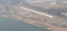
Pyongyang Heliport Facility (ICAO:ZKKK)[2] is a large heliport located next to the Taedong River in Pyongyang, North Korea.
Pyongyang Heliport Facility | |||||||||||
|---|---|---|---|---|---|---|---|---|---|---|---|
 | |||||||||||
| Summary | |||||||||||
| Opened | 2015 | ||||||||||
| Time zone | Pyongyang Time (UTC +09:00) | ||||||||||
| Elevation AMSL | 75 ft / 23[1] m | ||||||||||
| Coordinates | 39°2′57.71″N 125°48′22.49″E | ||||||||||
| Map | |||||||||||
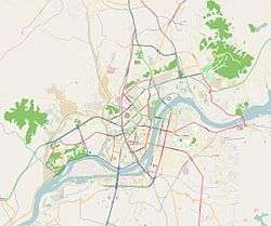 Pyongyang Heliport Facility Location within Pyongyang | |||||||||||
| Runways | |||||||||||
| |||||||||||
Early years
Before the construction of the current heliport a smaller heliport sat roughly 100 m from the heliport's current site, as recently as early 2014.[3] This site was much smaller the current site and although it is not known exactly when the original heliport was constructed, it had been on the site since at least the year 2000.[4]
Current heliport
Construction
Construction began on the current heliport, roughly 100m from the previous one, in late 2014, with the site being usable from mid-2015 and completely finished by late 2015.[5]
Design
The current heliport has a much larger runway, than the previous one, measuring approximately 800 meters in length,[6] which is long enough to accommodate many light aircraft,[7] which have been seen to visit the site and also the heliport has the notable feature of a large walled compound, 360 meters in length, featuring a football pitch and a basketball court, added in October 2015.[8]
References
- "Airport Records". Landings.com. Retrieved 17 January 2018.
- "Record of the Heliport in Pyongyang". Airport Records. Airport Records. Retrieved 20 May 2017.
- "Google Earth Satellite Imagery of Pyongyang 04/14/2014". Google Earth. CNES / Airbus. Retrieved 20 May 2017.
- "Google Earth Satellite Imagery of Pyongyang from 6/13/2000". Google Earth. Digital Globe. Retrieved 20 May 2017.
- "Google Earth Satellite Imagery of Pyongyang from10/27/2014 to 8/7/2015". Google Earth. Digital Globe and CNES / Airbus. Retrieved 20 May 2017.
- "Most Recent Google Earth Satellite Imagery of Pyongyang". Google Earth. CNES / Airbus. Retrieved 20 May 2017.
- "Data Table Showing Runway Requirements of Numerous Light Aircraft". corporatejetinvestor.com. Alud Davies. Retrieved 20 May 2017.
- "Google Earth Satellite Imagery of Pyongyang from 10/27/2015". Google Earth. Digital Globe. Retrieved 20 May 2017.