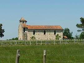
Puymangou
Puymangou is a former commune in the Dordogne department in southwestern France. On 1 January 2016, it was merged into the new commune Saint-Aulaye-Puymangou.[2]
Puymangou | |
|---|---|
Part of Saint-Aulaye-Puymangou | |
 | |
Location of Puymangou 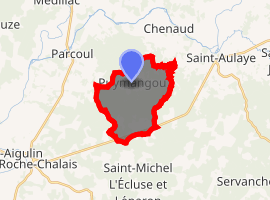
| |
 Puymangou  Puymangou | |
| Coordinates: 45°11′34″N 0°04′37″E | |
| Country | France |
| Region | Nouvelle-Aquitaine |
| Department | Dordogne |
| Arrondissement | Périgueux |
| Canton | Montpon-Ménestérol |
| Commune | Saint-Aulaye-Puymangou |
| Area 1 | 11.29 km2 (4.36 sq mi) |
| Population (2017)[1] | 70 |
| • Density | 6.2/km2 (16/sq mi) |
| Time zone | UTC+01:00 (CET) |
| • Summer (DST) | UTC+02:00 (CEST) |
| Postal code | 24410 |
| Elevation | 41–134 m (135–440 ft) (avg. 132 m or 433 ft) |
| 1 French Land Register data, which excludes lakes, ponds, glaciers > 1 km2 (0.386 sq mi or 247 acres) and river estuaries. | |
Population
| Year | Pop. | ±% |
|---|---|---|
| 1962 | 134 | — |
| 1968 | 147 | +9.7% |
| 1975 | 119 | −19.0% |
| 1982 | 98 | −17.6% |
| 1990 | 99 | +1.0% |
| 1999 | 101 | +2.0% |
| 2008 | 92 | −8.9% |
gollark: osmarkscalculator™ would have been waaaay slower to write in C.
gollark: ABR has had as many as three merged PRs, I think!
gollark: Instead of actually writing code, I can offload annoying parts to other people, sometimes.
gollark: Well, mine save me time.
gollark: Oh yes, imagine how horrible it would be if people could use your projects.
See also
References
- Téléchargement du fichier d'ensemble des populations légales en 2017, INSEE
- Arrêté préfectoral 14 December 2015 (in French)
| Wikimedia Commons has media related to Puymangou. |
| Authority control |
|
|---|
This article is issued from Wikipedia. The text is licensed under Creative Commons - Attribution - Sharealike. Additional terms may apply for the media files.