Provincial Route 11 (Buenos Aires)
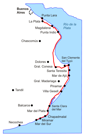
Provincial Route 11 is a 583-kilometre-long (362 mi) Argentine road in the East of Buenos Aires Province. The road extends from Punta Lara to the city of Mar del Sur [1]
| Provincial Route 11 | |
|---|---|
| Ruta Provincial 11 | |
 | |
| Route information | |
| Length | 583 km (362 mi) |
| Existed | 1932–present |
| Major junctions | |
| North end | Punta Lara |
| South end | Mar del Sur |
| Location | |
| Major cities | Punta Lara, La Plata, Magdalena, Punta Indio, Gral. Conesa, General Lavalle, San Clemente del Tuyú, Santa Teresita, Buenos Aires, San Bernardo, Mar de Ajó, Cariló, Pinamar, Villa Gesell, Santa Clara del Mar, Mar del Plata, Chapadmalal, Miramar |
| Highway system | |
| Highways in Argentina | |
Route 11 runs along the coasts of the Río de la Plata and the Atlantic Ocean, with a high number of car passing the road during summertime. The path between Magdalena and the intersection with Provincial Route 36 is still a graved road so the route has not been paved to date. On the other hand, from the crossing with Provincial Route 63 (popularly known as Esquina de Crotto[2]) to the city of General Conesa, the route becomes a dual carriageway, totalizing 30 km with two carriages per way. The stretch between Pinamar and Villa Gesell the route becomes a dual carriageway again.
This road contributed to development of the cities situated on the Buenos Aires Province coast at the Nort of Mar del Plata, due to the only town of the region reached by railway was Pinamar. The train that departed from General Guido until its terminus in Pinamar (a branch-line of Ferrocarril General Roca from Buenos Aires to Mar del Plata) operated from 1949 to 1968, being reestablished in December, 1996 [3][4] although in April 2011 was closed again, remaining inactive to date [5]
History
The beginning
.svg.png)
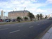
The first works on the road were made in the zone of Mar del Plata. The path between the downtown and Camet Park was paved in 1928, then followed by the pavement of the stretch to the Punta Mogotes lighthouse, finished in 1933.[6]
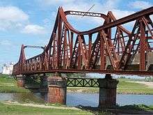
In 1932 the Camino de la Costa[7] a provincial road that extended from Avellaneda to Mar del Plata along with the coasts of the Río de la Plata and the Atlantic Ocean was opened. Four years later the coast road in Punta Lara was built. Nevertheless, the Sudestada (Southeast blow) caused a flooding that destroyed most of the road. For that reason, a wall was raised to avoid floodings; nevertheless, the water was eroding the wall until in July 1958, a new swell of the river brought down the wall, destroying the "Camino Costanero" (as Route 11 was also called). The flooding not only damaged the road but about 100,000 houses were devastated by the unstoppable course of the water [8]
The paved road from Mar del Plata and Miramar was built between 1937 and 1938,[9] while the stretch between La Plata and Magdalena was finished in 1961.[10]
Whten the pavement of Route 11 was definitely finished at the end of the 1970s, some parts of the original road were changed. The old path was farther from the coast.[11] The old path is still a graved road.[12]
In 1986 the Government of Buenos Aires Province transferred the stretch of the road crossing the urban area of Mar del Plata, to General Pueyrredón Partido [13] On December 5, 1987, the paved path from Miramar to Mar del Sur was opened to traffic [14]
Concession
On September 19, 1990, the contract of concession was signed. The management of the road was subsequently given to "Camino del Atlántico" ("Road of the Atlantic" in Spanish), which would take over the mainteneance of the Route from the intersection with Provincial Route 36 to the traffic circle access to Santa Clara del Mar. The contract was for a term of 15 years, with the option to be extended to 20 years through a special clause.[15] The toll booths were placed in "Paraje La Huella", near General Conesa, and Mar Chiquita.[16]
During 1996 the concessionary built a dual carriageway between the cities of Pinamar and Villa Gesell, financed by an increase of the toll rates which was made effective once the works finished.[17]
In December 2010 a 10 km path between Santa Clara del Mar and Parque Camet was openet. The works had a cost of $ 43 million.[18]
In July 2011 the Government of Buenos Aires traspassed the management of the Route 11 to "Autovía del Mar" for a term of 30 years. The company also manages Provincial routes Autovía 2, 63, 56, 74 and 36.[19]
Cities
Route 11 passes along the following cities from the beginning to its ending:
| Partido | City | Km |
|---|---|---|
| Ensenada | Punta Lara | 5 |
| La Plata | La Plata | 13 |
| Magdalena | Magdalena | 61 |
| Punta Indio | Punta Indio | 106 |
| Tordillo | Villa Roch | 245 |
| General Conesa | 250 | |
| General Lavalle | General Lavalle | 290 |
| La Costa | San Clemente del Tuyú | 308 |
| Las Toninas | 319 | |
| Santa Teresita | 324 | |
| Mar del Tuyú | 327 | |
| Costa del Este | 333 | |
| Aguas Verdes | 336 | |
| La Lucila del Mar | 339 | |
| San Bernardo | 331 | |
| Mar de Ajó | 345 | |
| Nueva Atlantis | 350 | |
| Pinar del Sol | 375 | |
| Costa Esmeralda | 382 | |
| Pinamar | Pinamar | 393 |
| Ostende | 396 | |
| Valeria del Mar | 398 | |
| Cariló | 400 | |
| Villa Gesell | Villa Gesell | 411 |
| Mar de las Pampas | 420 | |
| Mar Azul | 423 | |
| Mar Chiquita | Mar Chiquita | 483 |
| Mar de Cobo | 487 | |
| General Pueyrredón | Camet Norte | 494 |
| Atlántida | 500 | |
| Santa Elena | 501 | |
| Playa Dorada | 502 | |
| Mar del Plata | 514 | |
| Chapadmalal | 542 | |
| San Eduardo del Mar | 550 | |
| General Alvarado | Miramar | 562 |
| Mar del Sur | 578 | |
References
- "Nuestras Rutas", Dirección de Vialidad de la Provincia de Buenos Aires
- "La pulpería que sobrevive en el tiempo", La Nación, 2000-07-10
- Partido de Pinamar, Heráldica Argentina Archived 2008-12-07 at the Wayback Machine
- "El fondo de campo que llegó a ser centro turístico", María Cristina Coccari Archived 2009-08-22 at the Wayback Machine
- "Estado de los Trenes a Pinamar", Satélite Ferroviario website
- Cuatro años de gobierno 1936-1940, volumen IV Vialidad de la Provincia, 1940, editorial Guillermo Kraft, 1940
- Historia de Santa Teresita Archived 2013-09-19 at the Wayback Machine
- El Río de la Plata destruyó el Camino Costanero", Vialidad magazine #4, 1958
- Paseo Costanero Sur, Mar del Plata official website
- "Obras terminadas en el segundo semestre de 1961", Vialidad magazine #18, 1962
- República Argentina, red caminera principal, Automóvil Club Argentino (1969)
- Atlas de rutas Firestone Argentina, sur de Brasil, Chile, Paraguay, Uruguay, editorial Buenos Aires, 2007 - ISBN 987-21490-8-9
- Ordenanza 6488 del partido de General Pueyrredón, 1986-08-05.
- ""Partido de General Alvarado", Heráldica argentina". Archived from the original on 2008-12-07. Retrieved 2012-02-21.
- Documentación Ruta 11, Dirección Provincial de Vialidad
- ""Peajes en rutas argentinas", Automóvil Club Argentino, 2010". Archived from the original on 2011-05-31. Retrieved 2012-02-21.
- "Acta acuerdo de adecuación del contrato", Dirección de Vialidad de Buenos Aires
- "Inauguración de la autovía que une Mar del Plata y Santa Clara del Mar", Secretaría de Medios de la Provincia de Buenos Aires
- "Autovía del Mar es el nuevo concesionario de la Autovía 2", Notitrans, 1 July 2011