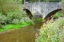
Prim (Neckar)
Prim is a river of Baden-Württemberg, Germany. It is a right tributary of the Neckar in Rottweil.[2]
| Prim | |
|---|---|
 | |
| Location | |
| Country | Germany |
| States | Baden-Württemberg |
| Physical characteristics | |
| Source | |
| • elevation | ca. 850 m |
| Mouth | |
• location | Neckar |
• coordinates | 48.1652°N 8.6462°E |
• elevation | 552,2 m |
| Length | 21.4 km (13.3 mi) [1] |
| Basin size | 141 km2 |
| Basin features | |
| Progression | Neckar→ Rhine→ North Sea |
Geography
Course
The river Prim has its source two kilometers north of Balgheim in the district of Tuttlingen. It flows southward in a forest klinge. After it leaves the steep valley the Prim flows to the north west. It flows in this direction till its meadow. The river Prim flows through Spaichingen and Aldingen, in between Aixheim and Frittlingen, and passes Neufra a district of Rottweil on the left. Then it flows north and passes the historic centre of Rottweil and its district Göllsdorf in the east. It merges with the Neckar next to Rottweils railway station.
Tributaries
from source to meadow
- Kehlengraben, from the right in Balgheim, 1,1 km.
- Hinterweiherbach, from the left auf unter 680 m above sea level by Balgheim, 0,6 km.
- Sandbrunnenbach, from the left in eastern Spaichingen, 0,7 km.
- Kälberbach, from the left in Spaichingen, 1,3 km and 0,7 km².
- Heidengraben, from the right in Spaichingen, 0,8 km.
- Unterbach, from the left in Spaichingen, 3,0 km and 5,2 km².
- Rohrentalbach, from the right im nördlichen Spaichingen, 2,3 km and 1,8 km².
- Talbach, from the left im nördlichen Spaichingen, 1,4 km.
- Schlüsselgraben, from the right, near the water treating plant of Spaichingen, 638,7 m above sea level, 1,3 km.
- Arbach, from the right am Südostrand Aldingens, 3,1 km and 3,1 km².
- Marbach, from the left , 2,7 km und 3,9 km².
- Heimbach, from the left in Aldingen, 3,6 km and 2,3 km².
- Heidlesbach, from the left in Aldingen, 1,8 km.
- Sulzbach, from the left 608,7 m above Sea level, 3,1 km and 3,8 km².
- Wettbach, from the right near the Erlenmühle, 7,1 km and 7,7 km².
- Tiefentalbach, from the right, 2,8 km und 3,7 km².
- Hagenbach, from the left auf 592,3 m ü. NN near the Aldinger Täfermühle, 7,4 km – with its more important tributary Trosselbach 9,0 km – and 25,9 km².
- Riedbach, from the right an der Täfermühle, 1,9 km.
- Katzenlochbach, from the left, 1,5 km.
- Vogelsangbach, also Sulztalbach, from the right 582,6 m above sea level, 6,4 km.
- Starzel, from the right in Neufra, 12,1 km und 25,1 km².
- Weiherbach, from the right, 3,7 km.
- Hinterer Graben, from the left near the water treating plant of Rottweil, 1,6 km.
- Weiherbach, from the right 554,3 m above sea level, 8,5 km und 18,2 km².
gollark: Okay, that might be problematic.
gollark: Excessive stuff is bad.
gollark: Minimal is fine.
gollark: I mostly just aim to put together something fairly nice-looking and leave most stuff to the browser's builtin stylesheets.
gollark: Also, my IDE can autocomplete CSS to some degree, which is helpful.
See also
References
- Map services of the Baden-Württemberg State Office for the Environment, Survey and Conservation (Landesanstalt für Umwelt, Messungen und Naturschutz Baden-Württemberg)
- Google (30 April 2018). "Prim" (Map). Google Maps. Google. Retrieved 30 April 2018.
This article is issued from Wikipedia. The text is licensed under Creative Commons - Attribution - Sharealike. Additional terms may apply for the media files.