Pratt Regional Airport
Pratt Regional Airport (IATA: PTT, ICAO: KPTT, FAA LID: PTT) is a public airport five miles north of Pratt, in Pratt County, Kansas.[1] Previously known as Pratt Industrial Airport, it is on the site of the former Pratt Army Airfield.
Pratt Regional Airport former Pratt AAF | |||||||||||
|---|---|---|---|---|---|---|---|---|---|---|---|
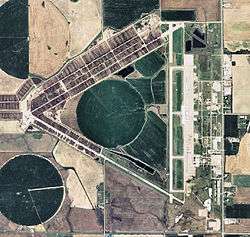 2008 USGS photo | |||||||||||
| Summary | |||||||||||
| Airport type | Public | ||||||||||
| Owner | Pratt Airport Authority | ||||||||||
| Serves | Pratt, Kansas | ||||||||||
| Elevation AMSL | 1,953 ft / 595 m | ||||||||||
| Coordinates | 37°42′09″N 098°44′49″W | ||||||||||
| Website | www.PrattAirportAuthority.com | ||||||||||
| Runways | |||||||||||
| |||||||||||
| Statistics (2008) | |||||||||||
| |||||||||||
Facilities
Pratt Regional Airport covers 2,569 acres (1,040 ha) at an elevation of 1,953 feet (595 m). Its one runway, 17/35, is 5,500 by 100 feet (1,676 x 30 m).[1] The facility had three 8,000 feet (2,400 m) runways: 13/31 (now closed), 04/22 (also closed), and runway 17/35 that has since been shortened by 2500 feet.
In the year ending August 13, 2008 the airport had 11,450 aircraft operations, average 31 per day: 96% general aviation, 3% air taxi, and 1% military. 25 aircraft were then based at this airport: 68% single-engine and 32% multi-engine.[1]
References
- FAA Airport Master Record for PTT (Form 5010 PDF). Federal Aviation Administration. Effective 30 June 2011.
External links
- Pratt Industrial Airport
- "Airport diagram and aerial photo" (PDF). from Kansas DOT Airport Directory
- Aerial photo as of 29 September 1991 from USGS The National Map
- FAA Terminal Procedures for PTT, effective August 13, 2020
- Resources for this airport:
- FAA airport information for PTT
- AirNav airport information for KPTT
- ASN accident history for PTT
- FlightAware airport information and live flight tracker
- NOAA/NWS weather observations: current, past three days
- SkyVector aeronautical chart, Terminal Procedures