Porters Pinnacles
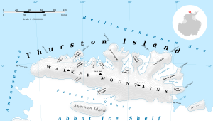
Porters Pinnacles is a group of low ice-covered rocks forming a menace to navigation along the north coast of Thurston Island, located about 4 nautical miles (7 km) north of the east extremity of Glacier Bight. Discovered by the U.S. Navy Bellingshausen Sea Expedition in February 1960, and named for Commander Philip W. Porter, Jr., U.S. Navy, commander of the icebreaker USS Glacier which made this discovery.

Map of Thurston Island.

Satellite image of Thurston Island.
Maps
- Thurston Island – Jones Mountains. 1:500000 Antarctica Sketch Map. US Geological Survey, 1967.
- Antarctic Digital Database (ADD). Scale 1:250000 topographic map of Antarctica. Scientific Committee on Antarctic Research (SCAR). Since 1993, regularly upgraded and updated.
gollark: Does gcd.hs work then, somehow?
gollark: That's suspiciously simple then, hm.
gollark: What's `findRem` doing? Doesn't Haskell have a mod function?
gollark: It's going to have a fun feature where if it detects that you're running it *while* the uninstaller is open, it will subtly mess up your answers.
gollark: After realizing I had absolutely no idea how the "general number field sieve" and such worked, I just decided to implement Pollard's ρ one, but it requires gcd which Lua doesn't have, so I'm looking up the Euclidean algorithm.
References
![]()
![]()
This article is issued from Wikipedia. The text is licensed under Creative Commons - Attribution - Sharealike. Additional terms may apply for the media files.