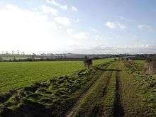
Port Way
Port Way[1] or the Portway[2] was a Roman road in Britain. It is sometimes taken to be the entire major route between Roman Londinium (present-day London) and Durnovaria (present-day Dorchester),[1] although it more precisely refers to the section of that route between Calleva of the Atrebates (present-day Silchester) and Sorviodunum (the abandoned site of Old Sarum).[2] (The portion between Calleva and Londinium going by the name "Devil's Highway".)
Route
Port Way runs northeast to southwest and covers a distance of 58 km (36 mi) from Calleva to Soviodunum, in present-day Hampshire and Wiltshire.[2][3] At East Anton, just outside Andover, it crossed the Roman Ermin Way, running from Venta of the Belgae (Winchester) to Cunetio (Mildenhall) and Corinium of the Dobunni (Cirencester).[2] The crossroads at East Anton provided the nucleus for a small town which formed after the two roads were built.[4]
Construction
Between the two towns are two prominent and intervisible high points: Cottington's Hill, south of Kingsclere, from which Silchester can be seen; and Quarley Hill, from which Old Sarum can be seen.[4] It is likely that these two high points provided the necessary locations for surveying the road.[4]
A section of the road in excellent preservation was carefully examined close to the Amesbury branch railway where the agger is very clear.[5] In the construction the surface soil had been cleared away, and a layer of chalk rubble laid down and cambered to give a thickness of 18 cm at the centre.[5] Upon this was a layer of large flints, 7.5–10 cm thick, which was topped with a layer of local gravel 30 cm thick and well cambered.[5] There were V-shaped ditches on each side of the road, 9.75 m from the south kerb and 10.45 m from the north kerb, making a total width for the road zone of 25.75 m to the ditch centres.[5]
References
| Wikimedia Commons has media related to Port Way. |
- Holmes, Edric. Wanderings in Wessex: An Exploration of the Southern Realm from Itchen to Otter. Robert Scott (London), 1922.
- Roman Roads from London to Silchester and the West, Thomas Codrington (1903) Roman Roads in Britain
- Johnston, David E. Discovering Roman Britain, pp. 63 f. Osprey, 2002.
- Michael Jonathan Taunton Lewis, (2001), Surveying instruments of Greece and Rome, page 234. Cambridge University Press.
- Ivan Donald Margary, (1957), Roman Roads in Britain: Volume 1
