Port Waikato
Port Waikato is on the south bank of the Waikato River at its outflow into the Tasman Sea, in northern New Zealand. It is currently a village of several hundred people.[1][2]
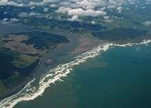
Port Waikato is a well-known surfing and whitebaiting destination and a popular holiday spot. Fish can be caught off the rocks and surf beach, and off the sand dunes that border the river mouth. Flounder and mullet are also plentiful using drag nets. Port Waikato is a location where sedimentary rock formations of 65–85 million years' antiquity are found,[3] and a Jurassic-period dinosaur fossil was found there.[4] Weathertop footage from the Lord of the Rings was filmed in limestone outcrops just south of the town.
The Port has a Wharf Store, established 1893, a take-away shop, café, campground, library, community hall, fire station, surf lifesaving club, yachting club and an active fishing club.[2] A school camp was established near the town in the 1920s, which boasts a well-formed BMX track. Port Waikato also serves as a popular wedding destination.[5]
History
Port Waikato was an important port during the New Zealand Wars of the 19th century.[6] It was the first of the colonial settlements to be constructed after the wars, being started in 1863. It had until then been called Putataka,[7] but soon the present name was in general use.[6] The Māori name remains for the 354 m (1,161 ft) hill above the town.[8]
For many years Port Waikato was the transhipment point between ships of the Northern Steamship Co and the river steamers of the Waikato Shipping Co, run by Caesar Roose.[9] The frequency increased to twice a week in 1924.[10] At the same time a Cambridge to Port Waikato excursion was being run two or three times a year, taking 12 to 14 hours downstream and a few hours longer upstream.[11] Now the only public transport is a morning and afternoon bus from Pukekohe on Thursdays.[12]
Marae
The local Ōraeroa Marae and its Whareroa meeting house is meeting place for the Waikato Tainui hapū of Ngāti Tāhinga and Ngāti Tiipa.[13][14]
Education
Te Kura Kaupapa o Puaha o Waikato is a co-educational state [Kura Kaupapa|Māori immersion]] primary school,[15] with a roll of 44 as of March 2020.[16]
See also
| Wikimedia Commons has media related to Port Waikato. |
- Port Waikato electorate
Neighbouring areas | ||||||||||
|---|---|---|---|---|---|---|---|---|---|---|
| ||||||||||
References
- The town straddles three meshblocks which had populations of 51, 228 and 162 in 2013. "2013 Census map – QuickStats about a place". www.stats.govt.nz. Retrieved 2016-06-05.
- "Port Waikato". www.waikatodistrict.govt.nz. Retrieved 2016-06-06.
- "Kiwi fossil hunter's very big find". The New Zealand Herald. 24 June 2008. Retrieved 24 February 2019.
- "Dinosaur hunter: Joan Wiffen". Stuff.co.nz. 31 January 2009. Retrieved 24 February 2019.
- "Port Waikato School Camp". Port Waikato School Camp. Retrieved 2015-07-10.
- "Port Waikato". New Zealand Herald. 1863-12-09. p. 3. Retrieved 2016-06-05.
- "Waikato". Otago Daily Times. 1864-01-19. p. 6. Retrieved 2016-06-05.
- "Putataka, Waikato - NZ Topo Map". NZ Topo Map. Retrieved 2016-06-05.
- "Page 1 Advertisements Column 4". Waikato Times. 1916-09-27. p. 1. Retrieved 2016-06-06.
- "Waikato River Trade". New Zealand Herald. 1926-03-31. p. 12. Retrieved 2016-06-06.
- Scenic River Trip - New Zealand Herald, Volume LXII, Issue 18947, 19 February 1925, Page 9
- "Southern Bus Timetable" (PDF). AT. 26 August 2018.
- "Te Kāhui Māngai directory". tkm.govt.nz. Te Puni Kōkiri.
- "Māori Maps". maorimaps.com. Te Potiki National Trust.
- "Ministry of Education School Profile". educationcounts.govt.nz. Ministry of Education.
- "Education Review Office Report". ero.govt.nz. Education Review Office.