Ponsorimalai
Ponsorimalai, also known as Sorimalai, is a hill in Vennandur block of Namakkal district in Tamil Nadu, India.
| Sorimalai | |
|---|---|
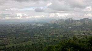 Aerial view of Vennandur block, view of Ponsorimalai and beyond that view of Kanjamalai from Alavaimalai | |
| Highest point | |
| Coordinates | 11°32′48.9″N 78°06′19.6″E |
| Dimensions | |
| Length | 2.575 km (1.600 mi) N–S |
| Width | 2.253 km (1.400 mi) E–W |
| Area | 5.8 km2 (2.2 sq mi) |
| Naming | |
| English translation | Ponsorimalai- பொன்சொரிமலை |
| Language of name | தமிழ் |
| Geography | |
| Location | Ponparappipatti |
| Parent range | part of the Eastern Ghats |
| Climbing | |
| Easiest route | Vennandur-Mallur Road |
Geology
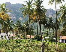
Ponsorimalai[1] is located northwest of Alavaimalai[2] and southeast of Kanjamalai.[3] North and West side foot hill limits are surrounded by villages of Salem district, South and East side foot hill limits are surrounded by villages of Namakkal district.
Ponsorimalai
History
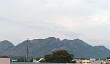
Ponsorimalai from Vennandur
Native people believed that some Jain monks lived here. Recently some inscriptions have been found, so some people in the foothills are not eating meat.
gollark: Hello ! Again !
gollark: Is AlexDevs a different account to the original Ale32bit?
gollark: Did you ,make a new account, instead of just renaming yours?
gollark: You're killing innocent ale!
gollark: Just do `/execute @e ~ ~ ~ summon ozelot ~ ~ ~`. I think that's the right command.
This article is issued from Wikipedia. The text is licensed under Creative Commons - Attribution - Sharealike. Additional terms may apply for the media files.