Pomeroy railway station
Pomeroy railway station served Pomeroy in County Tyrone in Northern Ireland.
Pomeroy | |
|---|---|
| Location | Pomeroy, County Tyrone Northern Ireland UK |
| History | |
| Original company | Portadown, Dungannon and Omagh Junction Railway |
| Post-grouping | Great Northern Railway |
| Key dates | |
| 2 September 1861 | Station opens |
| 15 February 1965 | Station closes |
The Portadown, Dungannon and Omagh Junction Railway opened the station on 2 September 1861. In 1876 it was taken over by the Great Northern Railway.
Throughout its history it had the highest altitude of any Irish gauge railway station in Ireland. West of Pomeroy the railway reached its summit, 561 feet (171 metres) above sea level,[1] the highest point on Ireland's Irish gauge network.
It closed on 15 February 1965.[2]
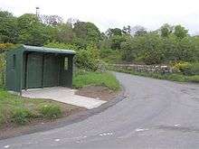
A Bus shelter at Cavankeeran, Pomeroy for Ulsterbus with a retaining wall from the former GNR.
Routes
| Preceding station | Disused railways | Following station | ||
|---|---|---|---|---|
| Donaghmore | Portadown, Dungannon and Omagh Junction Railway Portadown to Omagh |
Carrickmore |
gollark: youtube-dl's also available as a python library.
gollark: CLIs are waaay nicer for ease of use (on some things) and scripting.
gollark: ↑
gollark: Most open source projects are probably running Linux-based build servers and development environments.
gollark: `youtube-dl -x` then.
References
- Hajducki, S. Maxwell (1974). A Railway Atlas of Ireland. Newton Abbott: David & Charles. map 8. ISBN 0 7153 5167 2.
- "Pomeroy station" (PDF). Railscot - Irish Railways. Retrieved 29 April 2012.
This article is issued from Wikipedia. The text is licensed under Creative Commons - Attribution - Sharealike. Additional terms may apply for the media files.