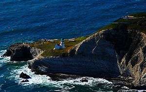
Point Conception
Point Conception (Chumash: Humqaq) is a headland along the Pacific coast of the U.S. state of California, located in southwestern Santa Barbara County. It is the point where the Santa Barbara Channel meets the Pacific Ocean, and as the corner between the mostly north-south trending portion of coast to the north and the east-west trending part of the coast near Santa Barbara, it makes a natural division between Southern and Central California,[1] and is commonly used as such in regional weather forecasts.[2] The Point Conception Lighthouse is at its tip.


Toponymy
Point Conception was first noted by Spanish maritime explorer Juan Rodriguez Cabrillo in 1542 and named Cabo de Galera. In 1602, Sebastian Vizcaíno sailed past again, renaming the protruding headland Punta de la Limpia Concepción[3] ("Point of the Immaculate Conception"). Vizcaíno's name stuck, and was later anglicized to today's version.
Chumash beliefs
The Chumash people of the region have traditionally known Point Conception as the "Western Gate", through which the souls of the dead could pass between the mortal world and the heavenly paradise of Similaqsa.[4]
It is called Humqaq ("The Raven Comes") in the Chumashan languages.[5]
in 1978, the Point Conception area was occupied "by Chumash and other Native Americans trying to save it from development by a liquefied natural gas company."[6]
References
- Characteristic patterns of shelf circulation at the boundary between central and southern California
- NWS Coastal Waters Forecast, accessed 3/18/2013.
- Gudde, Erwin G. (1969). California Place Names. Berkeley, CA: University of California Press. pp. 72. OCLC 47781.
- Anderson, John. "KUTA TEACHINGS: Reincarnation theology of the Chumash Indians of California". Retrieved 2013-05-07.
- Radic, Theo (2002). "The Chumash as the Keepers of the Western Gate". Syukhtun Editions. Retrieved 2013-05-07.
- Anderson, John. "Point Conception: The Chumash Western Gate". Retrieved 2013-05-07.
Further reading
Courtney Milne, Sacred Places in North America: A Journey into the Medicine Wheel (New York: Stewart, Tabori & Chang, 1995).