Pogal Paristan
Pogal Paristan is a tehsil located in the Ramban district in the union territory of Jammu and Kashmir. In 2014, it was carved out as a tehsil from Banihal tehsil. It is located 35 kilometres (22 mi) from its district headquarters in Ramban and 23 kilometres (14 mi) from Banihal.[1]
Pogal Paristan | |
|---|---|
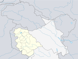
 Pogal Paristan Location in Jammu and Kashmir, India  Pogal Paristan Pogal Paristan (India) | |
| Coordinates: 33.313086°N 75.261806°E | |
| Country | |
| Union Territory | Jammu and Kashmir |
| District | Ramban |
| Languages | |
| • Official | Urdu |
| Local Languages | |
| • Spoken | Pogali, Kashmiri, Urdu |
| Time zone | UTC+5:30 (IST) |
| Pincode | 182145 |
| Website | ramban |
Etymology
Its name is derived from two valleys, Pongal and Pakistan. The Pogal valley lies on the southeast at the end of the Banihal tehsil, and a stream known as 'Sundari' or 'Pogal stream' that flows there. The stream flows toward the southern slopes of the Nandmarg mountains and joins the Paristan stream (a tributary of the Bichlari river) to flow in the southwestern direction. Paristan is a narrow valley situated at the southeast end of Banihal tehsil. The range of mountains on its south side features considerable elevation and forest-covered slopes. Relatively few hamlets in the area contain a considerable amount of cultivation.[2]
About
Pogal Paristan is a hilly area in the Ramban district made up of nine revenue villages, including Pogal, Alinbass, Panchal, Paristan, Bingara, Dhanmasta, Sujmatna, Ramsu, and Senabhati. The Tehsil headquarter is located in Ukhral village, 8 kilometres (5.0 mi) from National Highway 44 via Magarkote. [1]
Streams
The Pogal stream and the Paristan stream are the main streams in Pogal Paristan. The Pogal stream is also known as Sundari stream and later joins the Bichlari river.[2]
References
- "Places of Interest". Ramban administration (Government of Jammu and Kashmir). Retrieved 3 August 2020.
- "Pogal Paristan : Land of Fairies". Travel The Himalayas. 16 July 2019. Retrieved 4 August 2020.