Pluak Daeng District
Pluak Daeng (Thai: ปลวกแดง, pronounced [plùa̯k dɛ̄ːŋ]) is a district (amphoe) in the northwestern part of Rayong Province, eastern Thailand.
Pluak Daeng ปลวกแดง | |
|---|---|
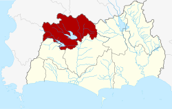 District location in Rayong Province | |
| Coordinates: 12°58′20″N 101°12′55″E | |
| Country | Thailand |
| Province | Rayong |
| Seat | Pluak Daeng |
| Tambon | 6 |
| Muban | 34 |
| Area | |
| • Total | 618.341 km2 (238.743 sq mi) |
| Population (2015) | |
| • Total | 58,258 |
| • Density | 94.2/km2 (244/sq mi) |
| Time zone | UTC+7 (ICT) |
| Postal code | 21140 |
| Geocode | 2106 |
Etymology
The name Pluak Daeng originates from the founding of the village. The villagers found an ant hill full of red termites (Thai: Pluak Daeng), different from those in other areas.
History
The area was originally part of Ban Khai District. The minor district (king amphoe) Pluak Daeng was established on 1 June 1970 consisting of the two tambons, Ta Sit and Pluak Daeng.[1] It was upgraded to a full district on 25 March 1979.[2]
Geography
Neighboring districts are (from the east clockwise) Wang Chan, Ban Khai, Nikhom Phatthana of Rayong Province, Bang Lamung, Si Racha and Nong Yai of Chonburi Province.
The important water resource is the Nong Pla Lai Reservoir
Administration
Central administration
Pluak Daeng is divided into six sub-districts (tambons), which are further subdivided into 34 administrative villages (mubans).
| No. | Name | Thai | Villages | Pop.[3] |
|---|---|---|---|---|
| 1. | Pluak Daeng | ปลวกแดง | 6 | 17,400 |
| 2. | Ta Sit | ตาสิทธิ์ | 4 | 7,622 |
| 3. | Lahan | ละหาร | 4 | 4,960 |
| 4. | Maenam Khu | แม่น้ำคู้ | 7 | 9,541 |
| 5. | Map Yang Phon | มาบยางพร | 7 | 14,381 |
| 6. | Nong Rai | หนองไร่ | 6 | 4,354 |
Local administration
There are two sub-district municipalities (thesaban tambons) in the district:
- Chomphon Chao Phraya (Thai: เทศบาลตำบลจอมพลเจ้าพระยา) consisting of parts of sub-district Ta Sit.
- Ban Pluak Daeng (Thai: เทศบาลตำบลบ้านปลวกแดง) consisting of parts of sub-district Pluak Daeng.
There are six sub-district administrative organizations (SAO) in the district:
- Pluak Daeng (Thai: องค์การบริหารส่วนตำบลปลวกแดง) consisting of parts of sub-district Pluak Daeng.
- Ta Sit (Thai: องค์การบริหารส่วนตำบลตาสิทธิ์) consisting of parts of sub-district Ta Sit.
- Lahan (Thai: องค์การบริหารส่วนตำบลละหาร) consisting of sub-district Lahan.
- Maenam Khu (Thai: องค์การบริหารส่วนตำบลแม่น้ำคู้) consisting of sub-district Maenam Khu.
- Map Yang Phon (Thai: องค์การบริหารส่วนตำบลมาบยางพร) consisting of sub-district Map Yang Phon.
- Nong Rai (Thai: องค์การบริหารส่วนตำบลหนองไร่) consisting of sub-district Nong Rai.
References
- ประกาศกระทรวงมหาดไทย เรื่อง แบ่งท้องที่ตั้งเป็นกิ่งอำเภอ กิ่งอำเภอปลวกแดง จังหวัดระยอง (PDF). Royal Gazette (in Thai). 87 (47 ง special): 12. June 1, 1970.
- พระราชกฤษฎีกาตั้งอำเภอหนองกุงศรี อำเภอไทรงาม อำเภอบ้านฝาง อำเภออุบลรัตน์ อำเภอเวียงชัย อำเภอดอยเต่า อำเภอนิคมคำสร้อย อำเภอนาหว้า อำเภอเสิงสาง อำเภอศรีสาคร อำเภอบึงสามพัน อำเภอนาดูน อำเภอค้อวัง อำเภอโพธิ์ชัย อำเภอเมืองสรวง อำเภอปลวกแดง อำเภอยางชุมน้อย อำเภอกาบเชิง อำเภอสุวรรณคูหา และอำเภอกุดข้าวปุ้น พ.ศ. ๒๕๒๒ (PDF). Royal Gazette (in Thai). 96 (42 ก Special): 19–24. March 25, 1979.
- "Population statistics 2015" (in Thai). Department of Provincial Administration. Retrieved 2016-08-24.