Playa Sardinas II
Playa Sardinas II is a barrio in the municipality of Culebra, Puerto Rico. Its population in 2010 was 64.[3][4][5]
Playa Sardinas II | |
|---|---|
Barrio | |
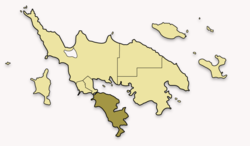 Map of Culebra highlighting Playa Sardina II | |
 Playa Sardinas II | |
| Coordinates: 18°17′16″N 65°17′06″W[1] | |
| Commonwealth | |
| Municipality | |
| Area | |
| • Total | 24.3 sq mi (63 km2) |
| • Land | 1.0 sq mi (3 km2) |
| • Water | 23.3 sq mi (60 km2) |
| Elevation | 0 ft (0 m) |
| Population (2010) | |
| • Total | 64 |
| • Density | 64/sq mi (25/km2) |
| Source: 2010 Census | |
| Time zone | UTC−4 (AST) |
Sectors
Barrios (which are like minor civil divisions)[6] in turn are further subdivided into smaller local populated place areas/units called sectores (sectors in English). The types of sectores may vary, from normally sector to urbanización to reparto to barriada to residencial, among others.[7][8][9]
The following sectors are in Playa Sardinas II barrio:[10]
Sector Ensenada Honda, and Sector Punta Aloe.
gollark: Also, problem: too much logic won't fit onto drone EEPROMs, so you either need a very cut down and minified program or network boot.
gollark: Why not route long deliveries through dedicated nether transport?
gollark: You probably also need to do something about powering them, for particularly long trips.
gollark: Maybe just have them automatically go back and upward if velocity drops to zero.
gollark: Maybe put GPS/linked card relay stations down periodically on longer routes, but have them navigate inertially between them.
References
- "US Gazetteer 2019". US Census. US Government.
- U.S. Geological Survey Geographic Names Information System: Playa Sardinas II barrio
- Picó, Rafael; Buitrago de Santiago, Zayda; Berrios, Hector H. Nueva geografía de Puerto Rico: física, económica, y social, por Rafael Picó. Con la colaboración de Zayda Buitrago de Santiago y Héctor H. Berrios. San Juan Editorial Universitaria, Universidad de Puerto Rico,1969.
- Gwillim Law (20 May 2015). Administrative Subdivisions of Countries: A Comprehensive World Reference, 1900 through 1998. McFarland. p. 300. ISBN 978-1-4766-0447-3. Retrieved 25 December 2018.
- Puerto Rico:2010:population and housing unit counts.pdf (PDF). U.S. Dept. of Commerce, Economics and Statistics Administration, U.S. Census Bureau. 2010.
- "US Census Barrio-Pueblo definition". factfinder.com. US Census. Archived from the original on 13 May 2017. Retrieved 5 January 2019.
- "Agencia: Oficina del Coordinador General para el Financiamiento Socioeconómico y la Autogestión (Proposed 2016 Budget)". Puerto Rico Budgets (in Spanish). Retrieved 28 June 2019.
- Rivera Quintero, Marcia (2014), El vuelo de la esperanza: Proyecto de las Comunidades Especiales Puerto Rico, 1997-2004 (first ed.), San Juan, Puerto Rico Fundación Sila M. Calderón, ISBN 978-0-9820806-1-0
- "Leyes del 2001". Lex Juris Puerto Rico (in Spanish). Retrieved 24 June 2020.
- "PRECINTO ELECTORAL CULEBRA 097" (PDF). Comisión Estatal de Elecciones (in Spanish). PR Government. 7 November 2018. Retrieved 24 June 2020.
This article is issued from Wikipedia. The text is licensed under Creative Commons - Attribution - Sharealike. Additional terms may apply for the media files.