Playa Sardinas I
Playa Sardinas I is a barrio in the municipality of Culebra, Puerto Rico. Its population in 2010 was 186.[3][4][5]
Playa Sardinas I | |
|---|---|
Barrio | |
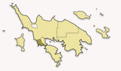 Map of Culebra highlighting Playa Sardinas I | |
 Playa Sardinas I | |
| Coordinates: 18°18′09″N 65°18′29″W[1] | |
| Commonwealth | |
| Municipality | |
| Area | |
| • Total | 6.53 sq mi (16.9 km2) |
| • Land | 0.19 sq mi (0.5 km2) |
| • Water | 6.34 sq mi (16.4 km2) |
| Elevation | 0 ft (0 m) |
| Population (2010) | |
| • Total | 186 |
| • Density | 978.9/sq mi (378.0/km2) |
| Source: 2010 Census | |
| Time zone | UTC−4 (AST) |
Sectors
Barrios (which are like minor civil divisions)[6] in turn are further subdivided into smaller local populated place areas/units called sectores (sectors in English). The types of sectores may vary, from normally sector to urbanización to reparto to barriada to residencial, among others.[7][8][9]
The following sectors are in Playa Sardinas I barrio:[10]
Égida Felipa Serrano.
gollark: That image has the feet cut off, so he's actually hiding government secrets.
gollark: No, it's from the birdsaren'treal thing.
gollark: At least use lossless compression.
gollark: I mean on the ban *page* it has a "funny" GIF or something. There was that thing with scanning a QR code to log in a while ago which was also made worse by them being unclear.
gollark: It's bad UX to make people have to try and search for useful features. Same with the "fun" messages on bans and whatnot instead of useful usable descriptions.
References
- "US Gazetteer 2019". US Census. US Government.
- U.S. Geological Survey Geographic Names Information System: Playa Sardinas I barrio
- Picó, Rafael; Buitrago de Santiago, Zayda; Berrios, Hector H. Nueva geografía de Puerto Rico: física, económica, y social, por Rafael Picó. Con la colaboración de Zayda Buitrago de Santiago y Héctor H. Berrios. San Juan Editorial Universitaria, Universidad de Puerto Rico,1969.
- Gwillim Law (20 May 2015). Administrative Subdivisions of Countries: A Comprehensive World Reference, 1900 through 1998. McFarland. p. 300. ISBN 978-1-4766-0447-3. Retrieved 25 December 2018.
- Puerto Rico:2010:population and housing unit counts.pdf (PDF). U.S. Dept. of Commerce, Economics and Statistics Administration, U.S. Census Bureau. 2010.
- "US Census Barrio-Pueblo definition". factfinder.com. US Census. Archived from the original on 13 May 2017. Retrieved 5 January 2019.
- "Agencia: Oficina del Coordinador General para el Financiamiento Socioeconómico y la Autogestión (Proposed 2016 Budget)". Puerto Rico Budgets (in Spanish). Retrieved 28 June 2019.
- Rivera Quintero, Marcia (2014), El vuelo de la esperanza: Proyecto de las Comunidades Especiales Puerto Rico, 1997-2004 (first ed.), San Juan, Puerto Rico Fundación Sila M. Calderón, ISBN 978-0-9820806-1-0
- "Leyes del 2001". Lex Juris Puerto Rico (in Spanish). Retrieved 24 June 2020.
- "PRECINTO ELECTORAL CULEBRA 097" (PDF). Comisión Estatal de Elecciones (in Spanish). PR Government. 7 November 2018. Retrieved 24 June 2020.
This article is issued from Wikipedia. The text is licensed under Creative Commons - Attribution - Sharealike. Additional terms may apply for the media files.