Planchón-Peteroa
Planchón-Peteroa is a complex volcano extending in a north-south direction along the border between Argentina and Chile. It consists of volcanoes of various ages with several overlapping calderas. Those include Volcán Planchón, Volcán Peteroa and Volcán Azufre.
| Planchón-Peteroa | |
|---|---|
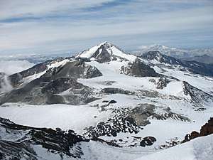 Peteroa as seen from the summit of Planchón. | |
| Highest point | |
| Elevation | 4,107 m (13,474 ft) |
| Coordinates | 35°14′24″S 70°34′12″W |
| Geography | |
| Location | Argentina-Chile |
| Parent range | Andes |
| Geology | |
| Mountain type | Complex volcano |
| Last eruption | February to June 2011[1] |
A partial collapse of the complex about 11,500 years ago produced a major debris avalanche, which followed the course of the Teno River until reaching the Chile Central Valley.
Peteroa has a crater lake. Lagunas de Teno lies at the foot of Planchón volcano. In this area also is the Vergara International Pass.
September 6, 2010 eruption
Planchón-Peteroa Volcano erupted on September 6, followed by a stronger eruption on September 18. On September 21, the volcano erupted once again, emitting a dark gray plume of volcanic ash. As winds blew the ash southeast into Argentina, residents there were warned by authorities to evacuate the nearby areas before Planchón-Peteroa would erupt again.