Pla Pak District
Pla Pak (Thai: ปลาปาก, pronounced [plāː pàːk]) is a district (amphoe) in the province Nakhon Phanom in northeast Thailand.
Pla Pak ปลาปาก | |
|---|---|
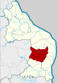 District location in Nakhon Phanom Province | |
| Coordinates: 17°10′50″N 104°31′34″E | |
| Country | Thailand |
| Province | Nakhon Phanom |
| Seat | Pla Pak |
| Area | |
| • Total | 547.1 km2 (211.2 sq mi) |
| Population (2005) | |
| • Total | 50,955 |
| • Density | 93.1/km2 (241/sq mi) |
| Time zone | UTC+7 (ICT) |
| Postal code | 48160 |
| Geocode | 4802 |
Geography
Neighboring districts are (from the north clockwise): Mueang Nakhon Phanom, Renu Nakhon, Na Kae, and Wang Yang of Nakhon Phanom Province; and Phon Na Kaeo and Kusuman of Sakon Nakhon Province.
History
The area of the district was at first a tambon of Mueang Nakhon Phanom District. On 16 June 1965 it became a minor district (king amphoe) consisting of the three tambons: Pla Pak, Nong Hi, and Ku Ta Kai.[1] The first district officer was Winai Bunratnaplin. On 17 November 1971 it was upgraded to a full district.[2]
Administration
The district is divided into eight sub-districts (tambons), which are further subdivided into 85 villages (mubans). Pla Pak itself has township (thesaban tambon) status and covers part of tambon Pla Pak. There are a further eight tambon administrative organizations (TAO).
| No. | Name | Thai name | Villages | Pop. | |
|---|---|---|---|---|---|
| 1. | Pla Pak | ปลาปาก | 16 | 10,159 | |
| 2. | Nong Hi | หนองฮี | 12 | 7,414 | |
| 3. | Kutakai | กุตาไก้ | 12 | 8,723 | |
| 4. | Khok Sawang | โคกสว่าง | 8 | 4,743 | |
| 5. | Khok Sung | โคกสูง | 10 | 5,316 | |
| 6. | Maha Chai | มหาชัย | 8 | 5,654 | |
| 7. | Na Makhuea | นามะเขือ | 11 | 5,895 | |
| 8. | Nong Thao Yai | หนองเทาใหญ่ | 8 | 3,051 |
References
- ประกาศกระทรวงมหาดไทย เรื่อง แบ่งท้องที่ตั้งเป็นกิ่งอำเภอ (PDF). Royal Gazette (in Thai). 81 (47 ง): 1616-. June 15, 1965.
- พระราชกฤษฎีกาตั้งอำเภอปลาปาก อำเภอเชียงกลาง อำเภอปากชม อำเภอบ้านม่วง อำเภอพังโคน อำเภอดอนสัก อำเภอพนม อำเภอเวียงสระ อำเภอสังคม และอำเภอหัวตะพาน พ.ศ. ๒๕๑๔ (PDF). Royal Gazette (in Thai). 88 (123 ก): 745–748. November 16, 1971.
External links
- Website Plapak website plapak.net
- amphoe.com