Piz Toissa
Piz Toissa is a mountain of the Oberhalbstein Alps, located west of Salouf in the canton of Graubünden.
| Piz Toissa | |
|---|---|
 Piz Toissa with Parsonz from Riom-Parsonz | |
| Highest point | |
| Elevation | 2,657 m (8,717 ft) |
| Prominence | 310 m (1,020 ft) [1] |
| Parent peak | Piz Platta |
| Isolation | 1.5 km (0.93 mi) |
| Coordinates | 46°37′8″N 9°31′29″E |
| Geography | |
 Piz Toissa Location in Switzerland | |
| Location | Graubünden, Switzerland |
| Parent range | Oberhalbstein Alps |
Panorama

360°-Panorama from Piz Toissa
Gallery
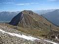 Piz Toissa and Ziteil from Piz Curvér
 Climb to Piz Toissa
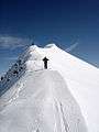 Climb to Piz Toissa
 Piz Toissa with road from Riom
gollark: osmarks.net is a very accursedly implemented site.
gollark: There is also the question of what a page is, and what should count as one.
gollark: Yes.
gollark: But not a list of all *pages*.
gollark: That exists, obviously.
References
- Retrieved from the Swisstopo topographic maps. The key col is the Furcletta (2,347 m).
This article is issued from Wikipedia. The text is licensed under Creative Commons - Attribution - Sharealike. Additional terms may apply for the media files.