Piz Fess
Piz Fess is a mountain of the Lepontine Alps, situated between the Val Lumnezia and Safiental in the canton of Graubünden. Piz Fess is the culminating point of the Signina range (Romansh: Cadeina dil Signina).
| Piz Fess | |
|---|---|
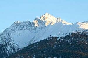 View from Laax (north side) | |
| Highest point | |
| Elevation | 2,880 m (9,450 ft) |
| Prominence | 501 m (1,644 ft) [1] |
| Parent peak | Rheinwaldhorn |
| Isolation | 9.7 km (6.0 mi) |
| Coordinates | 46°43′40.9″N 9°17′22.7″E |
| Geography | |
 Piz Fess Location in Switzerland | |
| Location | Graubünden, Switzerland |
| Parent range | Lepontine Alps |
| Climbing | |
| First ascent | 10 August 1895 by Karl Viescher, Wieland Wieland and J. Christoffel.[2] |
The mountain has two summits, a gentle summit named the Guter Fess ("Good Fess"; 2,874 m) and a not so gentle one named Böser Fess ("Angry Fess"; 2,880 m). In 1894 the pinnacle was still described as unclimbable, but the next summer Karl Viescher from Basel and the local guides Wieland Wieland and J. Christoffel reached the sharp summit.[2]
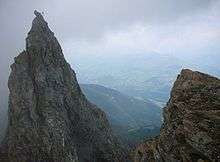
The summit of Böser Fess seen from the Guter Fess
References
- Swisstopo map
- W. Deriehsweiler, Das Safiental, Yearbook of the Swiss Alpin Club, 1919, p. 111
This article is issued from Wikipedia. The text is licensed under Creative Commons - Attribution - Sharealike. Additional terms may apply for the media files.