Piz Ela
Piz Ela is a mountain in the Albula Alps, overlooking Bergün, in the Swiss canton of Graubünden. It is located in the center of the nature park Parc Ela.
| Piz Ela | |
|---|---|
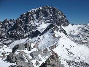 Piz Ela from the west side | |
| Highest point | |
| Elevation | 3,339 m (10,955 ft) |
| Prominence | 515 m (1,690 ft) [1] |
| Parent peak | Piz Calderas |
| Isolation | 6.3 km (3.9 mi) [2] |
| Coordinates | 46°36′07″N 9°42′28″E |
| Geography | |
 Piz Ela Location in Switzerland | |
| Location | Graubünden, Switzerland |
| Parent range | Albula Range |
There is a lake called Lai Grond to the south of Piz Ela.
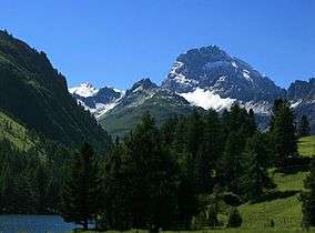
View from near the Albula Pass (east side)
References
- Retrieved from the Swisstopo topographic maps (1:25,000). The key col is north the Fuorcla da Tschitta (2,824 m).
- Retrieved from Google Earth. The nearest point of higher elevation is north of Piz d'Err.
This article is issued from Wikipedia. The text is licensed under Creative Commons - Attribution - Sharealike. Additional terms may apply for the media files.