Piz Corvatsch
Piz Corvatsch (![]()
| Piz Corvatsch | |
|---|---|
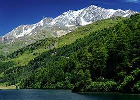 Piz Corvatsch seen from Lake Sils | |
| Highest point | |
| Elevation | 3,451 m (11,322 ft) |
| Prominence | 383 m (1,257 ft) [1] |
| Parent peak | Piz Bernina |
| Isolation | 5.2 km (3.2 mi) [2] |
| Coordinates | 46°24′30″N 9°48′58″E |
| Naming | |
| English translation | Crow (or raven) peak |
| Geography | |
 Piz Corvatsch Location in Switzerland | |
| Location | Graubünden, Switzerland |
| Parent range | Bernina Range |
| Climbing | |
| First ascent | 1850 by Johann Coaz and party[3] |
| Easiest route | From the Corvatsch station |
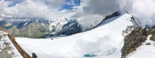
Several glaciers lie on the east side on the massif. The largest, below Piz Corvatsch, is named Vadret dal Murtèl. The second largest, below Piz Murtèl and the station, is named Vadret dal Corvatsch.
The Corvatsch cable car starts above the village of Surlej, east of Silvaplana and culminates at 3,298 m. From there, the summit of Piz Corvatsch can be reached by traversing Piz Murtèl. In winter and spring, the mountain is part of a ski area, which is amongst the highest in Switzerland and the Eastern Alps.
Climate
Piz Corvatsch has an alpine tundra climate (ET) with long, cold winters lasting most of the year and a brief period during summer where the average daily highs rise above freezing.
| Climate data for Piz Corvatsch (1981-2010) | |||||||||||||
|---|---|---|---|---|---|---|---|---|---|---|---|---|---|
| Month | Jan | Feb | Mar | Apr | May | Jun | Jul | Aug | Sep | Oct | Nov | Dec | Year |
| Average high °C (°F) | −8.6 (16.5) |
−9.5 (14.9) |
−8.2 (17.2) |
−6.0 (21.2) |
−1.5 (29.3) |
1.8 (35.2) |
4.8 (40.6) |
4.9 (40.8) |
1.6 (34.9) |
−1.0 (30.2) |
−5.7 (21.7) |
−8.0 (17.6) |
−3.0 (26.6) |
| Daily mean °C (°F) | −11.3 (11.7) |
−12.1 (10.2) |
−10.8 (12.6) |
−8.3 (17.1) |
−3.6 (25.5) |
−0.4 (31.3) |
2.3 (36.1) |
2.3 (36.1) |
−0.7 (30.7) |
−3.3 (26.1) |
−8.1 (17.4) |
−10.6 (12.9) |
−5.4 (22.3) |
| Average low °C (°F) | −13.8 (7.2) |
−14.8 (5.4) |
−13.4 (7.9) |
−10.7 (12.7) |
−5.9 (21.4) |
−2.7 (27.1) |
−0.2 (31.6) |
0.0 (32.0) |
−2.8 (27.0) |
−5.5 (22.1) |
−10.5 (13.1) |
−13.1 (8.4) |
−7.8 (18.0) |
| Average precipitation mm (inches) | 45 (1.8) |
41 (1.6) |
52 (2.0) |
68 (2.7) |
97 (3.8) |
104 (4.1) |
104 (4.1) |
105 (4.1) |
81 (3.2) |
77 (3.0) |
71 (2.8) |
56 (2.2) |
900 (35.4) |
| Average precipitation days (≥ 1.0 mm) | 6.9 | 6.4 | 8.6 | 10.8 | 13.3 | 12.9 | 11.9 | 11.8 | 9.0 | 8.9 | 9.1 | 8.1 | 117.7 |
| Average relative humidity (%) | 62 | 64 | 71 | 77 | 80 | 80 | 77 | 77 | 75 | 68 | 68 | 66 | 72 |
| Mean monthly sunshine hours | 149 | 160 | 188 | 171 | 177 | 182 | 216 | 195 | 181 | 179 | 135 | 130 | 2,063 |
| Source: MeteoSwiss [4] | |||||||||||||
See also
References
- Retrieved from the Swisstopo topographic maps. The key col is the Fuorcla Fex-Roseg (3,068 m).
- Retrieved from Google Earth. The nearest point of higher elevation is northwest of Piz Roseg.
- Collomb, Robin, Bernina Alps, Goring: West Col Productions, 1988, p. 109.
- "Climate Norm Value Tables". Climate diagrams and normals from Swiss measuring stations. Federal Office of Meteorology and Climatology (MeteoSwiss). Archived from the original on 14 May 2013. Retrieved 23 January 2013. The weather station elevation is 3305 meters above sea level.
- Collomb, Robin, Bernina Alps, Goring: West Col Productions, 1988
External links
![]()