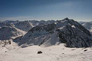
Piz Badus
Piz Badus or Six Madun is a mountain in the Lepontine Alps, lying on the border between the cantons of Uri and Graubünden.
| Piz Badus | |
|---|---|
| Six Madun | |
 | |
| Highest point | |
| Elevation | 2,928 m (9,606 ft) |
| Prominence | 529 m (1,736 ft) [1] |
| Parent peak | Piz Gannaretsch |
| Isolation | 4.35 km (2.70 mi) |
| Coordinates | 46°37′20″N 8°39′48″E |
| Geography | |
 Piz Badus Location in Switzerland | |
| Location | Uri/Graubünden, Switzerland |
| Parent range | Lepontine Alps |
| Climbing | |
| Easiest route | southeastern ridge from Val Maighels / Maighels hut |
In its northwestern face, which is the Graubünden side, lies Tomasee, source of the Anterior Rhine. It is possible to reach the lake on a path from Oberalp Pass, suitable for most walkers although still a mountain trail.[2]
References
- Swisstopo maps
- (in English)Hike Switzerland to the source of the Rhine in Graubünden
This article is issued from Wikipedia. The text is licensed under Creative Commons - Attribution - Sharealike. Additional terms may apply for the media files.