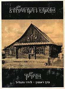
Pinkas haKehilot
Pinkas haKehillot or Pinkas Ha-kehilot, (Hebrew: פנקס הקהילות; notebook of the [Jewish] communities; plural: Pinkasei haKehillot) Encyclopedia of Jewish Communities from Their Foundation till after the Holocaust,[2] is the name of each volume of a series presenting collected historical information and demographic data on Eastern European countries' Jewish communities, most of which were depopulated and whose populations were exterminated in the Holocaust. Pinkasei haKehillot is one of the most important projects undertaken by Yad Vashem in Jerusalem, concisely documenting this aspect of the history of the Holocaust.[3][4]
 Book cover, series, sample.[1] | |
| Original title | פנקס הקהילות |
|---|---|
| Country | Israel |
| Language | Hebrew and Yiddish |
| Subject | History of the Holocaust |
| Publisher | Yad Vashem |
Content
Each volume of Pinkas Hakehillot is produced geographically, with locale names in Yiddish as well as the local language's version. The content is composed of collected documents, lists, personal memoirs in their original unedited form, historical accounts and essays devoted to the life of Jewish communities from antiquity until the present, including maps and period photographs. The Pinkas attempts to illustrate "the life that once was and is no more".
Awards
In 1973, the project was awarded the Israel Prize, for its special contribution to society and the State.[5] It receives financial support from the Memorial Foundation for Jewish Culture.[3]
Notes and references
- Book sample: The Communities of Lodz and its Region: List of the Communities, 1976, Yad Vashem, Jerusalem, 297 pages, Hebrew
- YIVO Institute for Jewish Research
- KOL haKEHILA, The Newsletter of the Jewish monuments of Greece
- "Rubin Mass Publishing, Israeli Books - Jewish Books all Israel books". Archived from the original on 2010-07-25. Retrieved 2010-10-19.
- "Israel Prize Official Site - Recipients in 1973 (in Hebrew)".