Pierre M. Lapie
Pierre M. Lapie was a French cartographer and engraver. He was the father of cartographer Alexandre Emile Lapie. Lapie was a Colonel in the French army, where he worked in the corps of topographical engineers.[1] Lapie worked closely with his son and published works together and individually. The work of Lapie and his son was influential on German commercial map makers in the 19th century.[2] Works by Lapie are held in the collection of the Library of Congress.[1]
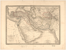
Map of Asian-Eastern Turkey, Persia, Afghanistan, and Arabia by Pierre M. Lapie
Works
- 1812, Atlas Classique et Universel
- 1842, Atlas universel de géographie ancienne et moderne with Alexandre Emile Lapie
Gallery
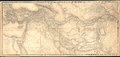 Map of Asian Turkey, Persia, Afghanistan, Balochistan, and the Khanate of Bukhara, with Some of the Neighboring Countries, 1848
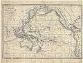 Map of the exploration of Australasia and Polynesia
.jpg)
| Wikimedia Commons has media related to Pierre M. Lapie. |
gollark: Maybe if you mix several lasers' beams? But tan is meant to be kind of dark.
gollark: I don't think tan is a spectral color.
gollark: You can also receive ADS-B yourself with an RTL-SDR, which is cool.
gollark: If I had to guess, low volume? I don't think there's a huge market for laser hobbyists.
gollark: Isn't that diagram a bunch of batteries in *parallel*, not series?
References
- "Map of Asian-Eastern Turkey, Persia, Afghanistan, and Arabia". World Digital Library. 1842. Retrieved 2013-07-27.
- "Pierre M. Lapie". Geographicus. Archived from the original on 15 August 2010. Retrieved 27 July 2013.
| Authority control |
|
|---|
This article is issued from Wikipedia. The text is licensed under Creative Commons - Attribution - Sharealike. Additional terms may apply for the media files.