Pic dels Aspres
Pic dels Aspres is a mountain in the northwest of the principality of Andorra, close to the border with Spain. The nearest town is Arinsal, La Massana.
| Pic dels Aspres | |
|---|---|
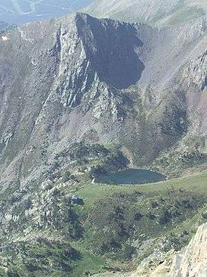 Pic del Aspres, Estany de les Truites and Refugi de Coma Pedrosa. | |
| Highest point | |
| Elevation | 2,562 m (8,406 ft) |
| Parent peak | Pic del Port Vell |
| Coordinates | 42°34′45″N 1°27′05″E |
| Geography | |
 Pic dels Aspres Location of Pic dels Aspres within La Massana parish, Andorra | |
| Location | La Massana parish, Andorra |
| Parent range | Pyrenees |
Geographic features
Some 250 metres below the summit is a round cirque, approximately 100 metres in diameter, which was formed by glacial erosion during the Last Glacial Maximum and which is now a lake, Estany de les Truites (the trout lake).
The valley to the south of the mountain is used as a ski area.
History
During the neolithic, sedentary populations inhabited the dels Aspres hills, and built megalithic dolmens in the area.[1]
gollark: I have *seen* a decent amount of shiny things, but mostly only caught coppers, during halloween when nobody was looking.
gollark: I do this to the extent of occasionally hunting for a bit on the 5 minute thingies, very unsuccessfully.
gollark: The only thing saving us from constant massbreed walls, really, is the fact that massbreeding is manually done and therefore slow and boring.
gollark: These things never end up actually being as simple as one would hope.
gollark: Programming effort.
References
- (in French) Banyuls-dels-Aspres, Les-pyrenees-orientales.com (accessed on 3 October 2019)
This article is issued from Wikipedia. The text is licensed under Creative Commons - Attribution - Sharealike. Additional terms may apply for the media files.