Phrom Buri District
Phrom Buri (Thai: พรหมบุรี, pronounced [pʰrōm bū.rīː]) is a district (amphoe) in the eastern part of Sing Buri Province, central Thailand.
Phrom Buri พรหมบุรี | |
|---|---|
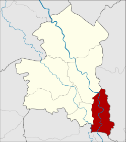 District location in Sing Buri Province | |
| Coordinates: 14°47′28″N 100°27′13″E | |
| Country | Thailand |
| Province | Sing Buri |
| Seat | Phrom Buri |
| Tambon | 7 |
| Muban | 42 |
| Area | |
| • Total | 82.5 km2 (31.9 sq mi) |
| Population (2014) | |
| • Total | 23,994 |
| • Density | 294.6/km2 (763/sq mi) |
| Time zone | UTC+7 (ICT) |
| Postal code | 16120 |
| Geocode | 1704 |
History
The town (mueang) of Phrom Buri dates back to before the reign of King U Thong, the first king of Ayutthaya kingdom. The old city was at Wat Amphawan, Tambon Phrom Buri. Later the center of the city was moved to Pak Bang Muen Han (ปากบางหมื่นหาญ) and to the north side of Wat Phromma Thephawat.
During the Thesaphiban reforms, Phrom Buri was one of the provinces included into Monthon Krungkao (later renamed to Monthon Ayutthaya) in 1895. It was later downgraded to a district in Sing Buri Province.
In 1943 the district office was moved to its present location on the north side of Wat Kudi Thong.
Geography
Neighboring districts are (from the east clockwise) Tha Wung of Lopburi Province, Chaiyo and Pho Thong of Ang Thong Province, Tha Chang and Mueang Sing Buri of Sing Buri Province.
Administration
Central administration
Phrom Buri is divided into seven sub-districts (tambons), which are further subdivided into 42 administrative villages (mubans).
| No. | Name | Thai | Villages | Pop.[1] |
|---|---|---|---|---|
| 1. | Phra Ngam | พระงาม | 6 | 3,800 |
| 2. | Phrom Buri | พรหมบุรี | 6 | 3,274 |
| 3. | Bang Nam Chiao | บางน้ำเชี่ยว | 6 | 3,665 |
| 4. | Ban Mo | บ้านหม้อ | 8 | 6,145 |
| 5. | Ban Paeng | บ้านแป้ง | 6 | 2,303 |
| 6. | Hua Pa | หัวป่า | 4 | 1,479 |
| 7. | Rong Chang | โรงช้าง | 6 | 3,328 |
Local administration
There are two sub-district municipalities (thesaban tambons) in the district:
- Bang Nam Chiao (Thai: เทศบาลตำบลบางน้ำเชี่ยว) consisting of sub-district Bang Nam Chiao.
- Phrom Buri (Thai: เทศบาลตำบลพรหมบุรี) consisting of sub-district Phrom Buri.
There are four sub-district administrative organizations (SAO) in the district:
- Phra Ngam (Thai: องค์การบริหารส่วนตำบลพระงาม) consisting of sub-district Phra Ngam.
- Ban Mo (Thai: องค์การบริหารส่วนตำบลบ้านหม้อ) consisting of sub-district Ban Mo.
- Ban Paeng (Thai: องค์การบริหารส่วนตำบลบ้านแป้ง) consisting of sub-district Ban Paeng.
- Rong Chang (Thai: องค์การบริหารส่วนตำบลโรงช้าง) consisting of sub-districts Rong Chang and Hua Pa.
References
- "Population statistics 2014" (in Thai). Department of Provincial Administration. Retrieved 2015-08-27.
External links
- amphoe.com (Thai)
| Historical divisions |
| ||||
|---|---|---|---|---|---|
| Former provinces |
| ||||