Phichunchäni
Phichunchäni (Aymara phichunchä a brownish-grey bird[2] (ä stands for a long a), -ni a suffix, "the one with the phichunchä bird", also spelled Pichunchani) is a mountain in the Andes of Peru which reaches a height of approximately 5,000 m (16,000 ft). It is located in the Arequipa Region, Arequipa Province, Tarucani District. Phichunchäni lies northwest of the Ubinas volcano.[1]
| Phichunchäni | |
|---|---|
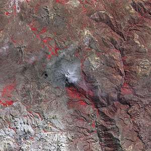 The Ubinas volcano and Phichunchäni northwest of it as seen from above (NASA, 2006) | |
| Highest point | |
| Elevation | 5,000 m (16,000 ft) [1] |
| Coordinates | 16°16′34″S 71°01′22″W |
| Geography | |
 Phichunchäni Peru | |
| Location | Peru, Arequipa Region |
| Parent range | Andes |
References
- escale.minedu.gob.pe - UGEL map of the General Sánchez Cerro Province (Arequipa Region)
- Radio San Gabriel, "Instituto Radiofonico de Promoción Aymara" (IRPA) 1993, Republicado por Instituto de las Lenguas y Literaturas Andinas-Amazónicas (ILLLA-A) 2011, Transcripción del Vocabulario de la Lengua Aymara, P. Ludovico Bertonio 1612 (Spanish-Aymara-Aymara-Spanish dictionary)
This article is issued from Wikipedia. The text is licensed under Creative Commons - Attribution - Sharealike. Additional terms may apply for the media files.