Phaq'u Q'awa (Sajama)
Phaq'u Q'awa is a mountain in the Cordillera Occidental in the Andes of Bolivia, about 5,380 metres (17,651 ft) high. It is situated in the Oruro Department, Sajama Province, in the west of the Curahuara de Carangas Municipality, northwest of the extinct Sajama volcano. It lies south of Qullqi Warani.
| Phaq'u Q'awa | |
|---|---|
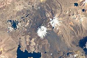 Satellite image showing the Paya Chata mountains and Phaq'u Q'awa northeast of them (upper right corner below the smaller lake, with north to the top right corner) | |
| Highest point | |
| Elevation | 5,380 m (17,650 ft) [1] |
| Coordinates | 18°05′30″S 69°04′08″W |
| Geography | |
 Phaq'u Q'awa Location in Bolivia | |
| Location | Bolivia |
| Parent range | Andes, Cordillera Occidental |
The river Junt'uma K'uchu (Aymara junt'u warm, hot, uma water, k'uchu corner, "warm water corner", Junthuma Khuchu) originates north of Phaq'u Q'awa. It flows to the southeast as a right affluent of the Sajama River.[1][2]
Name
Phaq'u Q'awa derives from Aymara language terms phaq'u, paqu,or p'aqu meaning the color light brown, reddish, fair-haired, or dark chestnut, and q'awa meaning little river, ditch, crevice, fissure, or gap in the earth,[3][4] the name thus meaning "brown brook" or "brown ravine". The Hispanicized spelling is Pacocahua or Pajojañua.[5][6][7]
References
- Bolivian IGM map 1:50,000 Nevados Payachata Hoja 5739-I
- "Curahuara de Carangas". Archived from the original on November 11, 2014. Retrieved September 15, 2014.
- Radio San Gabriel, "Instituto Radiofonico de Promoción Aymara" (IRPA) 1993, Republicado por Instituto de las Lenguas y Literaturas Andinas-Amazónicas (ILLLA-A) 2011, Transcripción del Vocabulario de la Lengua Aymara, P. Ludovico Bertonio 1612 (Spanish-Aymara-Aymara-Spanish dictionary)
- "Diccionario Bilingüe, Castellano - Aymara, Para: Tercera Edición". Félix Layme Pairumani. Archived from the original on September 2, 2013. Retrieved October 18, 2015.
- escale.minedu.gob.pe - UGEL map of the Candarave Province (Tacna Region)
- 00033-2009-AI - Tribunal Constitucional del Perú, October 2009
- Peru 1:100,000, Hospicio 2837, Map prepared and published by the Defense Mapping Agency, Hydrographic/Topographic Center, Bethesda, MD